Heat.net Store Home
|
ANTIQUE MAPS of 19TH CENTURY WORLD John Tallis Atlas Portland House 1st Ed HC DJ For Sale


When you click on links to various merchants on this site and make a purchase, this can result in this site earning a commission. Affiliate programs and affiliations include, but are not limited to, the eBay Partner Network.

ANTIQUE MAPS of 19TH CENTURY WORLD John Tallis Atlas Portland House 1st Ed HC DJ:
$49.99
The book measures 14\" x10½\" and has 179 pages on heavyweight, glossy stock, with 84 full colormaps.It was published by Portland House, New York, in 1989 andis a first edition, with full original dust jacket in like-newcondition.The beautifully colored antique maps present vivid andfascinating geographical portraits with accurate detail. Charmingvignettes depict cities, people and natural wonders of each country,and informative passages by Montgomery Martin,compiled from a variety of authoritative sources bring the 19th centuryworld to life.Condition: Book and dust jacket are in excellentcondition, bright andclean, with no rips, tears, writing, or turnedcorners, bound in dark blue cloth boards with gilt embossed letteringon the spine. Please see thescans and feel free to ask anyquestions. Buy with confidence! We are always happy to combineshipping on thepurchase of multiple items — just make sure to pay for everythingat one time, not individually.Powered by SixBit\'s eCommerce Solution
|
|
Other Related Items:
Related Items: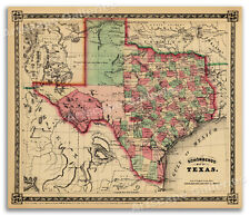
1866 Schönberg's Early Map of Texas Historic Map 24x28 $23.95
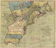
North America 1771 Colonial Map - 13 Colonies - 20x24 $16.95
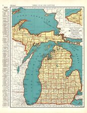
1941 Antique Michigan State Map Gallery Wall Decor Vintage Atlas Map 1581 $17.55
|
