When you click on links to various merchants on this site and make a purchase, this can result in this site earning a commission. Affiliate programs and affiliations include, but are not limited to, the eBay Partner Network.
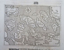
Up for sale is a LARGE original antique map - IMPERIUM CAROLI MAGNI OCCIDENTIS IMPERATORIS. Autore D. ROBERT DE VAUGONDY Geographo - Regis Ordinario cum privilegio.
Didier Robert de Vaugondy (1723, Paris – 1786) was an 18th-century French geographer.
This is an authentic, antique map of Western Europe during the time of Charlemagne's empire. The map was published in his 1757 issue of Atlas Universal out of Paris. Some hand-coloring along the edges of the land.
This map of Europe and the Empire of Charlemagne includes the British Isles, Denmark, the Low Countries, Germany, France, Spain, Switzerland, Austria, Italy, Hungary, Poland, the Balkans, Greece, and the northwest portion of Africa. The atlas with which the map was published in was one of the first to be based on actual surveys; therefor it is highly accurate for its period. Contemporary town named are given throughout as well as accurate delineations of river systems and other topographical features.
The son of Robert de Vaugondy, he was appointed geographer of the King by Louis XV, geographer of the Duke of Lorraine by Stanisław Leszczyński, King of Poland, Grand Duke of Lithuania, Duke of Lorraine. In 1773, he became royal censor for works related to geography, navigation and travels.
The map is on hand laid paper and has a beautiful drawing in the top left hand corner, around the title.
It is professionally matted and framed, under glass and measures approximately 29" x 26 1/2". The frame has some nicks, chips and scratches along the edges. There is an engraving at the bottom of the frame that reads - "ROBERT GERALD LIVINGSTON - Second President of the German Marshall fund 1977-1981 - From his Friends and Colleagues on the Board.
It has not been examined outside of the frame/glass. The map itself measures approximately 22" x 19".
The map is in Very Good condition. There is some age related browning and staining. There is a crease down the middle of the map. Other stains and dings here and there.
This is a GREAT MAP and these antique maps are such a fabulous piece of history!
Please note shipping charges.
Please email me with any questions and see my store for other great items.