When you click on links to various merchants on this site and make a purchase, this can result in this site earning a commission. Affiliate programs and affiliations include, but are not limited to, the eBay Partner Network.

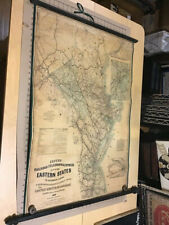
Original 1863 Mitchell Map CINCINNATI Ohio River Bridge Ferry Canal Railroads:
$79.99
Handsomeoriginal antique hand-colored 1863 street map of Cincinnati andvicinity. - The map locates two ferrycrossings on the Ohio River, and it shows work in progress on the JohnA. Roebling Suspension Bridge, originally known as theCincinnati-Covington Bridge. When the bridge opened in 1866, threeyears after this map was printed, it was the longest suspension bridgein the world.
- It labels the Miami and White Water canals and theproposed Short Line Railroad parallel to Deer Creek Road. Other namedrailroads include the Cincinnati, Hamilton &Dayton; the Ohio & Mississippi; the Cincinnati &Indianapolis;and the Little Miami.
- Among the other named places and features on the mapare the Lebanon Turnpike, Mill Creek, Washington Park, Licking River,Gas Works, Public Landing, Western Museum, Montgomery Turnpike,Newport, Covington, Observatory,Apollo Building, German Theatre, and St. John\'s College, as well as theboundaries of the city\'s 16 wards.
- The imagearea measures 27.4 x 28.7 cm [10¾\" x 11¼\"], with wide margins at leftand right.
- The map has a decorative floral border and is dated 1860in the lower margin. It was published in Mitchell\'s New General Atlas,S. Augustus Mitchell, Jr., Philadelphia, 1863.
- It is an original, authentic antique map, not areproduction or modern reprint, and it is fully guaranteed to begenuine.
- Condition: It is in excellent condition,brightand clean, with nomarks, rips, or tears. It is blank on the back, with no printing on thereverse side. Please see the scansand feel free to ask any questions.
- It would make a very attractive display in your den oroffice,and we\'ll include our helpful framing tips for your reference.
- Buy with confidence! We are always happy to combineshipping on thepurchase of multiple items — just make sure to pay for everythingat one time, not individually.
Powered by SixBit\'s eCommerce Solution
|