When you click on links to various merchants on this site and make a purchase, this can result in this site earning a commission. Affiliate programs and affiliations include, but are not limited to, the eBay Partner Network.
More than 425 of my reproductioncloth maps have been sold to date worldwide with 100% buyer satisfaction.
Bulk orderdiscountsare available. Please message me for details.
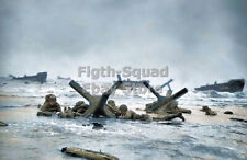
These maps are reproductions of the highly sought after WW2 ZONES OF FRANCEescape/evasionmap issued to paratroopers and aircrews flying missions over Europe during WW2 (especially D-Day). Originallycommissioned by Intelligence School No. 9(IS9) in February 1944in preparation for the upcoming invasion,these maps were issued in escape kits along with a small compass and hacksaw blade (see my other listings) just prior to the invasion.
I have worked for more than 3 years to create onethe best reproductions ever made of this highly sought after cloth map. Created using an original map that was jumped into Normandy on D-Day, it holdsthe characteristics of the original map including the size, color, shape, and feel. Printed on a cotton/silk blend fabric, it perfectly matches the weight, feel,texture, and opacityof my original map (see comparison photos for reference).
Each map is approximately 58.5cmx60cm same as my original.
The soft cotton/silk fabricmakes for a comfortable scarf as seen in many original photographs which helped prevent chafing on the wearers neck from the abrasive wool collar of the wearer'sservice shirt. These reproductions have an "unfinished" edge just like originals. If you look at the attached original picture of 1st Lt. Carl Macdowell on his C-47 before taking off forD-Day, you will see the unfinished edges of his map starting to fray. (Note: If you would like to prevent the edges of your map from fraying simply fold the edges and sew them down)
These make great display or practical use pieces at a fraction of the cost of an original map and if you tie it as a scarf around your neck (as pictured) it is indistinguishable from anoriginal.
The Zones of France map was designed as an "escape map" meaning that it was printed on a rather small bit of fabric (58.5cmx60cm) which could be hidden easily on the body when captured as well as it was printed in an exceptionally large 1:2,000,000 scale. That being the case the map was not very useful for traditional military land navigation. There are no gridlines and much of the smaller print is difficult if not impossible to read even under a magnifying glass due to its large scale as well being printed on the porous surface of fabric instead of the smooth surface of paper. Rather it was used primarily to determine a person's general geographic location so they could plan a route to "neutral" counties like Switzerland and Spain and be smuggled back to England.
This listing is for 1 reproduction map (see picture 1 in this listing). Original map (see picture 2), on which this reproduction was produced is not included in this sale.
Special note for international buyers (buyers outside the US): international shipping costs cover the postage for the order but maybe subject to customs fees unique to your country. Seller is not responsible for any additional postage or customs fees.
Special note to those who own original Zones of France maps. This reproduction may not match your specific original map perfectly. A brief internet search will show you that there were many different manufactures of these maps all using different looms, printers, and materials. Although they were all printed on the same kind of fabric, the qualities of that fabric could vary from roll to roll in different factories. Dimensions of the maps can also vary as much as an inch in width and/or height. As you can see in the listingpictures, this mapis an extremely faithful reproduction of the original, so faithful in fact that I have added a small makers mark to the map legend to identify it as an original. If you would like further detailed pictures prior to ordering, don't hesitate to message me.
.