When you click on links to various merchants on this site and make a purchase, this can result in this site earning a commission. Affiliate programs and affiliations include, but are not limited to, the eBay Partner Network.
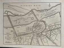
Plan of Dunkirk with the Canal of Mardick by John Cary, circa 1790.
This beautiful map is printed on one side only and measures 27 cm x 20 cm or 10\" x 8\".
If you have any questions or would like to see more photographs then please do not hesitate to ask. This interesting map is an original antique which is over 230 years old.
John Cary (c. 1754 – 1835) was an English cartographer.Cary served his apprenticeship as an engraver in London, before setting up his own business in the Strand in 1783. He soon gained a reputation for his maps and globes, his atlas, The New and Correct English Atlas published in 1787, becoming a standard reference work in England.
In 1794 Cary was commissioned by the Postmaster General to survey England\'s roads. This resulted in Cary\'s New Itinerary (1798), a map of all the major roads in England and Wales. He also produced Ordnance Survey maps prior to 1805.
In his later life he collaborated on geological maps with the geologist William Smith. His business was eventually taken over by G. F. Cruchley (1822–1875).
Please click on this link to view my other listings which you will find categorised on the left side of the