When you click on links to various merchants on this site and make a purchase, this can result in this site earning a commission. Affiliate programs and affiliations include, but are not limited to, the eBay Partner Network.
Johann Baptista Homann
Germany, ca. 1664–1724
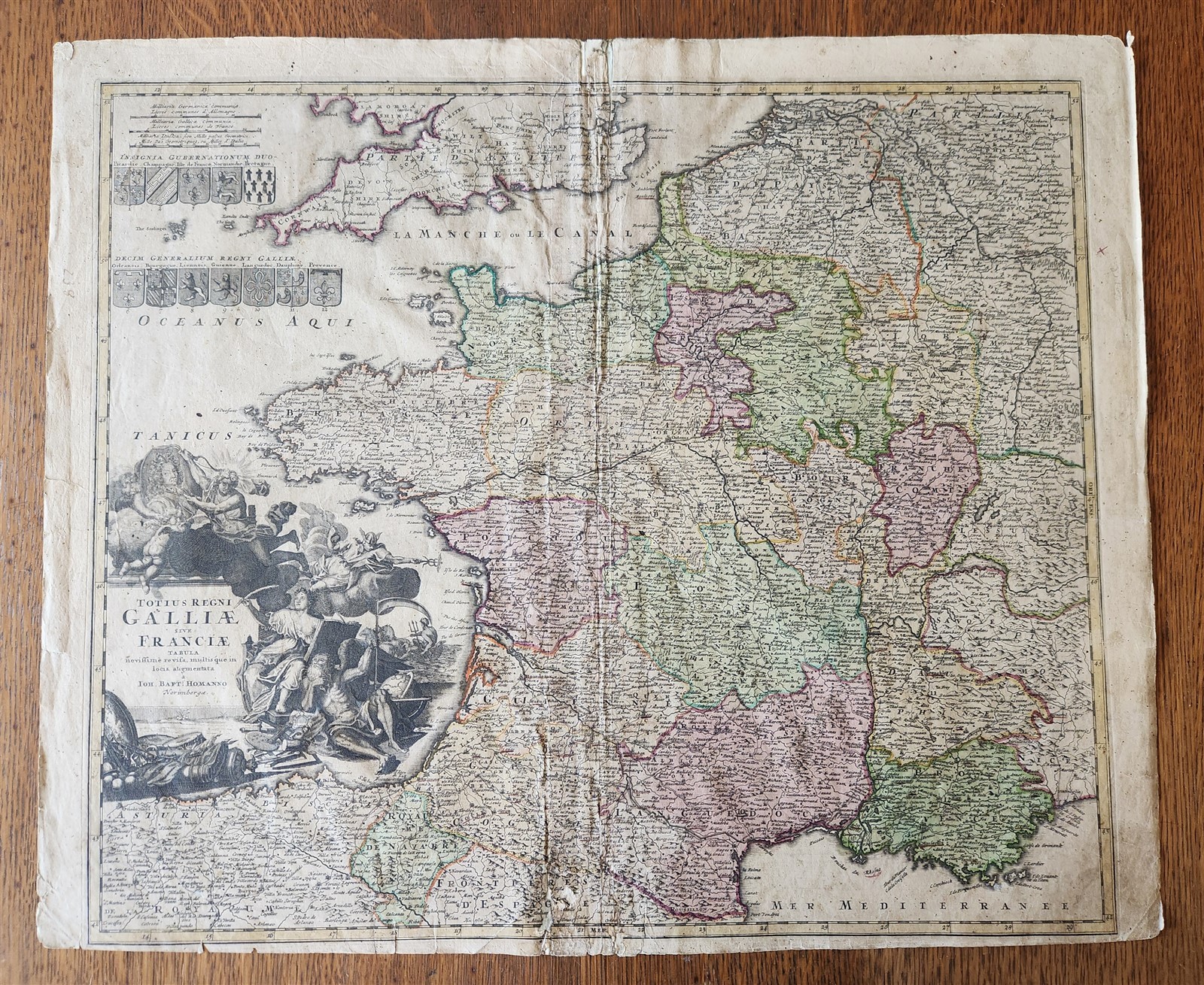
A Map of France
Totius Regni Galliae sive Franciae Tabula . . .
Hand-colored etching on paper, undated (Nuremberg, 1720)
Size 20.5 by 24.5 inches
Themap depicts France and a small portion of the southern British Isles.
With fortified cities, towns, roads, rivers, mountains, and more.
With black-and-white cartouche which includes portrait of King Louis XV and images of Neptune and Mercury.
Also there are 12 coats of arms for the regions of France in the upper left corner.
Some wear, fold in the middle repaired on the backside
Johann Baptist Homann (20 March 1664 – 1 July 1724) was a German geographer and cartographer, who also made maps of the Americas.
Homann was born in Oberkammlach near Kammlach in the Electorate of Bavaria. Although educated at a Jesuit school, and preparing for an ecclesiastical career, he eventually converted to Protestantism and from 1687 worked as a civil law notary in Nuremberg. He soon turned to engraving and cartography; in 1702 he founded his own publishing house.
Homann acquired renown as a leading German cartographer, and in 1715 was appointed Imperial Geographer by Holy Roman Emperor Charles VI. Giving such privileges to individuals was an added right that the Holy Roman Emperor enjoyed. In the same year he was also named a member of the Prussian Academy of Sciences in Berlin. Of particular significance to cartography were the imperial printing privileges (Latin: privilegia impressoria). These protected for a time the authors in all scientific fields such as printers, copper engravers, map makers and publishers. They were also very important as a recommendation for potential customers.
In 1716 Homann published his masterpiece Grosser Atlas ueber die ganze Welt (Grand Atlas of all the World). Numerous maps were drawn up in cooperation with the engraver Christoph Weigel the Elder, who also published Siebmachers Wappenbuch.
Homann died in Nuremberg in 1724. He was succeeded by his son Johann Christoph (1703–1730). The company carried on upon his death as Homann heirs company, managed by Johann Michael Franz and Johann Georg Ebersberger. After subsequent changes in management the company folded in 1852.[1] The company was known as \"Homann Erben\", \"Homanniani Heredes\", or \"Heritiers de Homann\" abroad.
Please see my other sales
Thank You
Refund Policy: We will issue a FULL REFUND, 100% money back if you are not satisfied with your purchase. Items must be returned to us within 20 days in order to receive a refund or replacement. Buyer is responsible for shipping costs.
Powered by SixBit\'s eCommerce Solution