When you click on links to various merchants on this site and make a purchase, this can result in this site earning a commission. Affiliate programs and affiliations include, but are not limited to, the eBay Partner Network.
Transcription of All Text
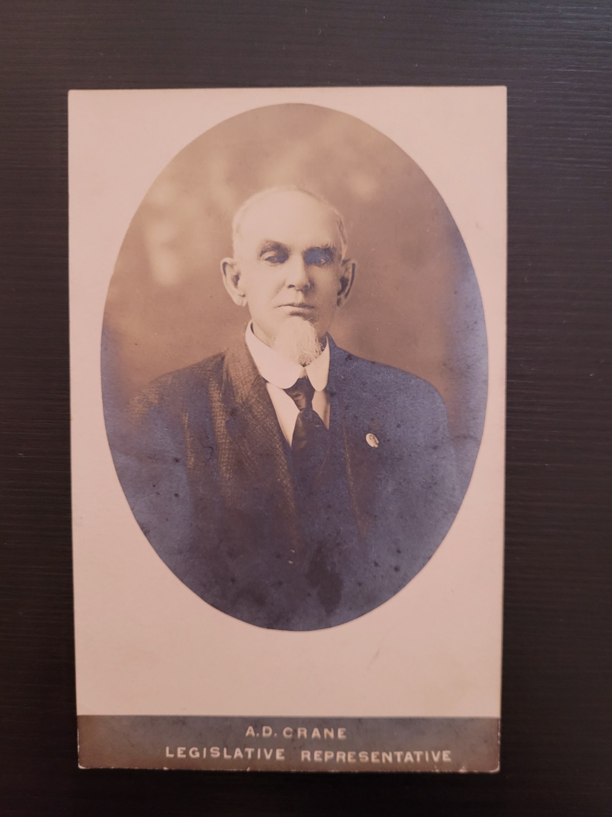
Front (Printed Bottom Border): A.D. CRANE / LEGISLATIVE REPRESENTATIVE
Back (Top Right - Stamp Box): AZO (with upward-pointing triangles surrounding the letters in the corners of the stamp box, indicating a real photo postcard produced between 1904 and 1918)
Back (Top Center): POST CARD
Back (Divided Back Labels): CORRESPONDENCE HERE | NAME AND ADDRESS HERE
Back (Handwritten on Left Side): Dexter Michigan
History of the Item
The Format: This is a Real Photo Postcard (RPPC). The back features an AZO stamp box with triangles pointing up, which dates the photographic paper stock to the 1904–1918 era.
The Subject: A.D. Crane is identified as a \"Legislative Representative,\" indicating he served as an advocate, lobbyist, or official political delegate representing local interests (such as the Dexter or Washtenaw County area in Michigan). Early local historical figures like A.D. Crane frequently tied into regional political machinery, community leadership, and historical events (such as early Washtenaw County governance and local pioneers).
The Location: The handwritten annotation on the reverse explicitly points to Dexter, Michigan, a historic village in Washtenaw County northwest of Ann Arbor.
Biography: Judge A.D. Crane of Dexter, Michigan
Early Regional Involvement & The Toledo War: A.D. Crane was a notable early figure in Dexter, Michigan, participating in the foundational events of the region as Michigan pushed toward statehood. During the summer of 1835, when border disputes with Ohio erupted into the Toledo War, local Dexter men took part in the regional skirmishes under Crane\'s leadership.
Civil War Leadership: As the community grew, Crane stepped forward during times of national crisis. At the outbreak of the American Civil War in May 1861, the Michigan Argus reported that the Dexter Union Guard was formed with 80 able-bodied men. A.D. Crane, alongside Harrison Jeffords, led this local guard as they mustered into service to become Company K of the Fourth Michigan Regiment.
Civic and Judicial Standing: In the decades following his military and civic leadership, Crane remained a pillar of the local community. He was recognized as a prominent local leader, holding the title of Judge and serving as a legislative representative.
Washtenaw Pioneer Society: Because of his deep historical roots in the region, Judge A.D. Crane was an active participant in organizations like the Washtenaw County Pioneer Society, which was dedicated to preserving theearly historical records, milestones, and relics of Michigan\'s pioneering generation
A.D. Crane in Michigan historically refers to Hon. Alexander Dallas Crane (1809–1893), a prominent pioneer, lawyer, circuit court judge, and Civil War captain from Dexter in Washtenaw County.Life and CareerEarly Pioneer: Born in May 1837 or earlier settled in the Dexter area, working as a local attorney and community leader.Toledo War: Participated as a local leader among Dexter men during the bloodless Michigan-Ohio boundary dispute known as the Toledo War in 1835.Civil War Service: Commanded Company K (the Dexter Union Guards) of the Fourth Michigan Infantry as a Captain in 1861 before resigning due to illness.Judicial & Public Roles: Served the county in multiple capacities, including as a Justice of the Peace and as a Judge of the Washtenaw County Circuit is a city in Washtenaw County, Michigan, in the United States. As of the 2020 United States census, the population was 4,500.[4]
Established as a village in 1830, Dexter was incorporated as a city in 2014.[5] It lies approximately nine miles northwest of Ann Arbor, the county seat of Washtenaw County, and 40 miles west of Detroit, the largest city in the state.
HistoryThe area that became Dexter was settled in 1824 by land speculator and lawyer Samuel W. Dexter, who purchased a tract of land at the confluence of Mill Creek and the Huron River.[6] Prior to white settlement, the area was home to members of the Potawatomi tribe.[7] Dexter was the village\'s first postmaster and became the first chief justice of Washtenaw County when it was formally organized in 1826, earning the nickname \"Judge Dexter\" for the rest of his life.[6] The settlement, originally known as the Mill Creek Settlement, was officially platted in 1830 and renamed Dexter in honor of Dexter\'s father, Samuel Dexter, a former U.S. senator and cabinet member under President John Adams.[8]
In the early 1840s, Dexter built a Greek Revival-style residence northwest of the village known as Gordon Hall (named after Dexter\'s mother, Catherine Gordon Dexter), which has since become a prominent local landmark.[9] The property has been associated by historians with abolitionist activity and possible involvement with the Underground Railroad.[10][11]
Many of the buildings in Dexter\'s downtown were constructed in the 1870s after a series of major fires along Main Street and the surrounding areas destroyed much of the original wood structures.[7]
On March 20, 1966, the Dexter area was the site of a widely reported unidentified flying object sighting that received national media coverage.[12][13] Multiple residents and law enforcement officers reported sightings of unexplained lights near marshlands north of Dexter. Working as a U.S. Air Force consultant, astronomer J. Allen Hynek attributed the sightings to atmospheric phenomena he described as \"swamp gas\". The explanation was met with plenty of skepticism and prompted then-Congressman Gerald R. Ford to call for a congressional investigation. The incident remains a notable episode in Dexter\'s modern history and reputation.Tornado outside of Brass CreekOn March 15, 2012, an EF3 tornado struck Dexter and the surrounding area of Washtenaw County, producing wind speeds estimated at 135-140 mph and carving a path of damage over seven miles long.[14] More than 250 residences were affected, and the area faced losses of approximately $12 million. No fatalities or serious injuries were reported, but the event was the most destructive tornado to impact Washtenaw County in decades and prompted a federal disaster response.[15]
A 2014 survey completed by Eastern Michigan University recommended the Downtown Dexter Historic District as \"likely eligible for listing in the National Register of Historic Places\".[7] Gordon Hall had been listed on the register since 1972.[16][17]
Dexter residents voted on November 4, 2014, to adopt a city charter under Michigan\'s Home Rule Act, ending the municipality\'s status as a village.[18] Officials cited increased administrative efficiency and the benefits of unified governance as primary motivations for the change, which was nearly a decade in the making.[19]
GeographyAccording to the U.S. Census Bureau, Dexter has a total area of 1.97 square miles (5.10 km2), of which 1.94 square miles (5.02 km2) is land and 0.03 square miles (0.08 km2) (1.52%) is water.[1]
Washtenaw County\'s Border-to-Border Trail runs through the city, which also contains small portions of two metro parks: Hudson Mills Metropark and Dexter–Huron Metropark.[20]
The city is located along Mill Creek and the Huron River.
Adjacent municipalitiesSource:[21]
Scio Township (east, south, and west)Webster Township (north)Dexter Township (northwest)DemographicsHistorical populationCensus Pop. Note %±1850 850 —1860 856 0.7%1870 1,161 35.6%1880 1,008 −13.2%1890 879 −12.8%1900 900 2.4%1910 726 −19.3%1920 587 −19.1%1930 894 52.3%1940 1,087 21.6%1950 1,307 20.2%1960 1,702 30.2%1970 1,729 1.6%1980 1,524 −11.9%1990 1,497 −1.8%2000 2,338 56.2%2010 4,067 74.0%2020 4,500 10.6%U.S. Decennial Census[22]2020 censusAs of the 2020 census, Dexter had a population of 4,500 and a population density of 2,284.3 inhabitants per square mile (882.0/km2). The median age was 40.6 years. 26.2% of residents were under the age of 18 and 17.2% were 65 years of age or older. For every 100 females there were 88.1 males, and for every 100 females age 18 and over there were 85.3 males age 18 and over. Dexter\'s population grew 10.6% from 2010 to 2020.[23][24][25]
99.4% of residents lived in urban areas, while 0.6% lived in rural areas.[26]
There were 1,796 households in Dexter, of which 37.0% had children under the age of 18 living in them. Of all households, 53.6% were married-couple households, 13.5% were households with a male householder and no spouse or partner present, and 28.3% were households with a female householder and no spouse or partner present. About 28.7% of all households were made up of individuals and 13.4% had someone living alone who was 65 years of age or older.[24]
There were 1,894 housing units, of which 5.2% were vacant. The homeowner vacancy rate was 1.3% and the rental vacancy rate was 2.8%.[24][25]
Racial composition as of the 2020 census[25]Race Number PercentWhite 3,972 88.3%Black or African American 25 0.6%American Indian and Alaska Native 9 0.2%Asian 122 2.7%Native Hawaiian and Other Pacific Islander 1 0.0%Some other race 49 1.1%Two or more races 322 7.2%Hispanic or Latino (of any race) 215 4.8%Income and povertyThe median household income was $106,637, and the median family income was $140,192. About 0.8% of families and 0.8% of the population were below the poverty line, including 0.0% of those under age 18 and 0.4% of those age 65 or over.[27]
2010 censusAs of the 2010 census,[28] there were 4,067 people, 1,590 households, and 1,067 families residing in the city. The population density was 2,174.9 inhabitants per square mile (839.7/km2). There were 1,704 housing units at an average density of 911.2 per square mile (351.8/km2). The racial makeup of the city was 92.7% White, 1.1% African American, 0.4% Native American, 2.8% Asian, 0.8% from other races, and 2.2% from two or more races. Hispanic or Latino people of any race were 2.8% of the population. Dexter\'s population grew 62.9% from 2000 to 2010, the largest growth in the state during that period.[29]
The median age in the city was 36.2 years, and the gender makeup was 47.1% male and 52.9% female. 31% of residents were under the age of 18; 4.8% were between the ages of 18 and 24; 32.6% were from 25 to 44; 23.2% were from 45 to 64; and 8.6% were 65 years of age or older.
There were 1,590 households, of which 42.6% had children under the age of 18 living with them, 51.8% were married couples living together, 12.3% had a female householder with no husband present, 3.1% had a male householder with no wife present, and 32.9% were non-families. 28.2% of all households were made up of individuals, and 8.7% had someone living alone who was 65 years of age or older. The average household size was 2.56, and the average family size was 3.20.
2000 censusAt the 2000 census,[2] there were 2,338 people, 1,013 households, and 641 families residing in the city. The population density was 1,236.7 inhabitants per square mile (477.5/km2). There were 1,106 housing units at an average density of 585.0 per square mile (225.9/km2). The racial makeup of the city was 96.58% White, 0.43% African American, 0.30% Native American, 1.03% Asian, 0.26% from other races, and 1.41% from two or more races. Hispanic or Latino people of any race were 0.98% of the population.
The median age in the city was 34 years, and the gender makeup was 48.7% male and 51.3% female. 26.4% of the population were under the age of 18, 6.6% from 18 to 24, 38.1% from 25 to 44, 19.0% from 45 to 64, and 9.8% were 65 years of age or older.
There were 1,013 households, of which 34.5% had children under the age of 18 living with them, 46.6% were married couples living together, 13.2% had a female householder with no husband present, and 36.7% were non-families. 32.3% of all households were made up of individuals, and 9.0% had someone living alone who was 65 years of age or older. The average household size was 2.31, and the average family size was 2.92.
The median household income was $50,510, and the median family income was $62,697. About 2.8% of families and 4.5% of the population were below the poverty line, including 6.3% of those under age 18 and 3.7% of those age 65 or over.
GovernmentDexter operates under a council–manager form of government, with legislative authority held by an elected mayor and six elected council members (all nonpartisan) and day-to-day administration handled by a council-appointed city manager.[30]
Shawn Keough was elected as the city’s first mayor following Dexter’s incorporation as a city in 2014, after having served as village president since 2007.[31] Keough was reelected to a second four-year term in 2022.[32] As of 2026, Dexter\'s six city council members are Sanam Aldag, Wa-Louisa Hubbard, Pavlo Popov, Daniel Schlaff, Joseph Semifero, and Ray Tell. Two Dexter area students are appointed for one-year terms as student representatives to the council.[33][34] Justin Breyer has been the city manager since 2021.[35]
In addition to elected and administrative officials, Dexter maintains several appointed boards and commissions to assist with municipal governance and planning, including the Planning Commission, Downtown Development Authority, Parks and Recreation Commission, Tree Board, and Zoning Board of Appeals.[36] Fire and rescue services are contracted to the Dexter Area Fire Department, while law enforcement services are contracted to the Washtenaw County Sheriff’s Office.[37] The city operates municipal water and wastewater systems through its Department of Public Services.[38]
Dexter is administered separately from Dexter Township, which sits northwest of the city and includes the unincorporated communities of Dover and Hudson Mills.[39]
TransportationThe Western-Washtenaw Area Value Express (WAVE) Community Connector Bus[40] stops at several Dexter locations daily and on weekends. Its regular route travels between Chelsea and Ann Arbor, where it transfers to Ann Arbor Area Transportation Authority (TheRide) Bus #30.
Downtown Dexter\'s main thoroughfares were originally known as A, B, C, D, and E Streets. Today, these are known as Alpine, Broad, Central, Dover, and Edison Streets.[41] Residential areas in Dexter include the original settlements along Baker Road, Central Street, and Dexter-Ann Arbor Road, as well as newer subdivisions and condominiums. The city has 411 on-street public parking spaces and more than 300 spaces across six public parking lots, the largest of which (Main St.) has 175 spaces. Parking is free throughout the city.[42]
Dexter-Ann Arbor Road, the primary roadway between the two cities, was originally designated state highway M-132 in 1931 as part of an early network of spur routes intended to improve regional connectivity. The route lost its state highway status and was returned to local control in 1960 after the expansion of the Interstate and freeway systems.[43] The Chicago-Montreal Highway, proposed by state officials in the 1930s to stretch from New Buffalo to Port Huron, was planned to pass through Dexter as part of a new diagonal trunkline route. With the exception of a few constructed bypasses, no work on the Chicago-Montreal Highway was ever completed.[44]
The city used to have a train depot, built in 1841 when the Michigan Central Railroad came through Dexter while running between Detroit and St. Joseph (or Chicago), but no trains currently stop there. Today, the station is home to the Ann Arbor Model Railroad Club.[45] Amtrak\'s Wolverine service between Chicago and Pontiac travels through the city, with a stop in nearby Ann Arbor.[46][47]
Education
Mill Creek Middle SchoolDexter Community Schools (DCS) is the public school district that includes the city of Dexter and the surrounding rural areas in Washtenaw and Livingston counties.[48] Dexter High School was ranked 37th among high schools in Michigan by U.S. News & World Report in 2025. DCS is part of the larger Washtenaw Intermediate School District, which serves most of the county.
Dexter is also served by several nearby private and charter schools, including Daycroft School, Emerson School, and Honey Creek Community School.[49][50][51] The Dexter Cooperative Nursery School is a non-profit community-run preschool.[52]
Since 2012, Dexter High School has offered an International Baccalaureate Diploma Programme.[53]
Arts and cultureThe Encore Musical Theatre Company was founded in 2008 by Broadway actor and Michigan native Dan Cooney, along with Anne and Paul Koch, at 3126 Broad Street.[54] The company operates as a nonprofit organization and stages professional musical theatre productions featuring a mix of Broadway performers and local talent. Encore is recognized by the Actors\' Equity Association. In 2020, Encore purchased the historic Copeland Building at 7714 Ann Arbor Street from Dexter Community Schools as part of a long-term plan to establish a permanent performance venue in downtown Dexter.[55]
The Dexter Area Historical Society preserves the city\'s local history through exhibits, educational programming, and public events. The organization is involved in the stewardship of historic properties and supports community efforts to document and share Dexter’s historical and cultural heritage.[56]
The Dexter Summer Festival is an annual community festival held in downtown Dexter. Formerly called Dexter Daze, the event was rebranded in 2024. The two-day summer celebration features live music, food vendors, artisans from across Michigan, games, and family-friendly activities, and is one of the city’s largest recurring community events.[57][58]
The Dexter Cider Mill, established in 1886, claims to be the oldest continuously operating cider mill in the state. Located along the Huron River, it serves as a popular attraction for residents and visitors.[59][60]
MediaThe Sun Times News, a weekly newspaper covering Dexter, Chelsea, and other nearby cities in Washtenaw County, is the primary print newspaper dedicated to Dexter. The paper is delivered for free to over 30,000 residences and over 1,500 businesses in the area.[61] In 2025, the Sun Times was acquired by TrUiC (The Really Useful Information Company),[62] which assumed responsibility for the paper\'s business operations.[63]
Regional coverage of Dexter is provided by The Ann Arbor News through MLive.com, which regularly reports on Dexter-area government, development, and community events.
The Dexter Leader was a weekly newspaper founded in 1869.[64] In 1995, it was absorbed by the Chelsea Standard[65] after Detroit-based Heritage Newspapers purchased both papers from Walter and Helen Leonard, a married couple who had owned and operated both papers since 1947.[66][67] The Standard and Leader were sold six years later, along with the Saline Reporter, Milan News-Leader, Manchester Enterprise, and Ypsilanti Courier, after the death of Heritage owner and founder Heinz Prechter in 2001. The papers passed through various stages of bankruptcy and ownership, eventually merging into a single publication, Washtenaw Now, under the ownership of Digital First Media, a newspaper publisher owned by hedge fund Alden Global Capital. Washtenaw Now shut down in June 2015 after just 14 months of publication, 146 years after the Leader was founded.[68][69][70]
The first newspaper in Dexter was the Western Emigrant, printed by Judge Samuel Dexter in 1829.[7] The Emigrant evolved over the years and by 1835 was known as the State Journal (not to be confused with the current Lansing State Journal).
Dexter High School publishes The Squall, a student-run newspaper that primarily serves the school community but offers subscriptions to local residents.
Athletics
Monument ParkIn 2025, the Dexter High School Dreadnaughts football team made their first-ever Michigan High School Athletic Association (MHSAA) Division 2 state championship appearance, losing 51-14 to Orchard Lake St. Mary\'s in the championship game at Ford Field.[71][72] Dexter\'s men\'s cross country team won five consecutive MHSAA state championships from 2002 to 2006, tying the state record for most consecutive titles.[73] Other notable high school sports programs include field hockey, soccer, and water polo.[74]
Founded in 1978, the Dexter Ringers Horseshoe Club is a long-running competitive horseshoe league that plays its annual summer season at First Street Park on Edison Street in Dexter. The club welcomes participants from Dexter and surrounding communities and donates the proceeds from each season to charitable causes.[75]
The Dexter Baseball Club, which later became Dexter Little League (DLL),[76] was formed in 2003 and is the local youth baseball and softball organization serving the Dexter area. The DLL hosted the 8-10 boys\' state baseball tournament in 2019.[77]
Since 2011, Dexter has been home to a vintage base ball team, the Union Base Ball Club of Dexter, which competes using 19th-century rules, uniforms, and equipment.[78]
Notable peopleCole Cabana, American football running back who was part of Michigan\'s 2023 national championship teamDr. Royal S. Copeland, U.S. senator from New York and sponsor of early food and drug legislation[79]Benny Frey, a Major League Baseball player who pitched for the Cincinnati RedsArthur Hills, golf course architect[80]Harrison Jeffords, colonel in the Union Army and a hero of the Battle of Gettysburg[81]Mark Koernke, right-wing militia movement leader and conspiracy theorist[82][83]Rob Malda, open-source software proponent and founder of Slashdot[84]Katharine Dexter McCormick, biologist, women\'s suffragette, and philanthropist; known as the \"mother of the pill,\" she funded the research that led to the birth control pill (along with Margaret Sanger)[85]Edie Parker, Beat figure and wife of Jack Kerouac; Kerouac-Parker\'s family owned the Oak Ridge Farm in Dexter[86][87]Milo Radulovich, a symbol of 1950s Red Scare resistance who was featured on journalist Edward R. Murrow\'s October 20, 1953, episode of See It Now[88]Abigail Tamer, Olympic field hockey player and member of the United States women’s national field hockey team
Washtenaw County (/ˈwɔːʃtənɔː/ WAWSH-tə-naw) is a county located in the U.S. state of Michigan. At the 2020 census, the population was 372,258.[3] The county seat and largest city is Ann Arbor.[4] The county was authorized by legislation in 1822 and organized as a county in 1826.[1] Washtenaw County comprises the Ann Arbor Metropolitan Statistical Area. The county is home to the University of Michigan, Eastern Michigan University, Washtenaw Community College, and Concordia University Ann Arbor.
HistoryNative American territoriesThe first peoples occupying the central portion of what is now Michigan included: \"the Pottawattamies, the Chippewas, the Ottawas, the Wyandottes and the Hurons\".[5] Native Americans whose territories included land within the Washtenaw County boundaries are shown to have included: Myaamia (Miami),[6] Bodéwadmiké (Potawatomi),[7] Anishinabewaki ᐊᓂᔑᓈᐯᐗᑭ,[8] Peoria,[9] Meškwahki·aša·hina (Meskwaki),[10] and the Mississauga nation.[11]
Etymology of WashtenawIn the Ojibwe language, \"Wash-ten-ong\" or \"Owashtanong\" literally translates as \"far away waters\", and was then used by the Ojibwe as the name for the Grand River due to its great length.[5][1][12] At the time of the official naming of the county in 1822, the headwaters of the Grand River fell within the original boundaries of Washtenaw County, which encompassed a much larger area than the present county.[1]
Early colonizationThe earliest histories mention French trappers and traders conducting trade in the area at the Potawatomi Trail and Pontiac Trail crossings of the Huron River, and later English then American settlers. The first successful settlement was established at the present site of Ypsilanti about 1809 by French traders.[13]
In 1822, the Legislative Council of Michigan Territory government defined the name and boundaries of the county, but attached it to Wayne County for revenue, taxation and judicial affairs. Four years after the first platting out of the county, Washtenaw was established as a separate self-administered county by an act of the Michigan Territorial Legislature, in 1826.[13] It was attached for administrative purposes to Wayne County until (before 1829) when county government was seated. Ingham and other counties were formed from portions of territorial Washtenaw County.
Swamps were drained to lower the water table. The swamp northwest of the I-94 and US-23 intersection, and areas within Waterloo Recreation Area still appear as they did to early settlers. As productive farms became established, the local deer herds grew. In the 1820s and 1830s, the events surrounding the independence of Greece from Turkey inspired construction of Greek Revival buildings, and the names of townships, towns, and children.
The \"frostbitten convention\" was held at Ann Arbor, the county seat, in 1835. Statehood was delayed because Michigan claimed the Toledo Strip, which was also claimed by Ohio. Following resolution of the Toledo War (1835–1836), in which Michigan Territory ceded its claim to Toledo in exchange for most of the Upper Peninsula (from the Porcupine Mountains eastward), Ohio withdrew its objection and Michigan became a state on January 26, 1837.
The convention also decided to move the capital from Detroit to a point further away from the Canadian border. After considering many existing communities, the delegates decided to build an entirely new capital city, which became Lansing. The University of Michigan, founded at Detroit in 1817, was moved to Ann Arbor in 1839 as a consolation for the city not being named the new state capital, as it had sought. The university subsequently became and remains Washtenaw County\'s largest employer.
In 1849, the Michigan State Normal School (now Eastern Michigan University) was established in Washtenaw\'s oldest settlement, Ypsilanti. It was elevated to collegiate status c. 1891 as Michigan State Normal College. The name was changed in 1956 to Eastern Michigan College, which was elevated to university status in 1959.[citation needed]
Geography
Business Loop Interstate 94/Business US Highway 23 (BL I-94/Bus. US 23, Washtenaw Avenue) in Ann ArborAccording to the U.S. Census Bureau, the county has a total area of 722 square miles (1,870 km2), of which 706 square miles (1,830 km2) is land and 16 square miles (41 km2) (2.3%) is water.[14]
Adjacent countiesLivingston County (north)Oakland County (northeast)Wayne County (east)Monroe County (southeast)Lenawee County (southwest)Jackson County (west)Ingham County (northwest)Major highwaysI-94BL I-94US 12 (Michigan Avenue, Chicago Road)
Bus. US 12US 23
Bus. US 23M-14M-17M-52M-153 (Ford Road)DemographicsHistorical populationCensus Pop. Note %±1830 4,042 —1840 23,571 483.2%1850 28,567 21.2%1860 35,686 24.9%1870 41,434 16.1%1880 41,848 1.0%1890 42,210 0.9%1900 47,761 13.2%1910 44,714 −6.4%1920 49,520 10.7%1930 65,530 32.3%1940 80,810 23.3%1950 134,606 66.6%1960 172,440 28.1%1970 234,103 35.8%1980 264,748 13.1%1990 282,937 6.9%2000 322,895 14.1%2010 344,791 6.8%2020 372,258 8.0%2025 (est.) 370,214 [15] Decrease −0.5%U.S. Decennial Census[16]1790–1960[17] 1900–1990[18]1990–2000[19] 2010–2019[3]
2020 population density of Washtenaw County MI by census block[20]Racial and ethnic compositionWashtenaw County, Michigan – Racial and ethnic compositionNote: the US Census treats Hispanic/Latino as an ethnic category. This table excludes Latinos from the racial categories and assigns them to a separate category. Hispanics/Latinos may be of any race.Race / Ethnicity (NH = Non-Hispanic) Pop 1980 Pop 1990 Pop 2000[21] Pop 2010[22] Pop 2020[23] % 1980 % 1990 % 2000 % 2010 % 2020White alone (NH) 224,512 232,938 245,033 248,675 252,220 84.80% 82.33% 75.89% 72.12% 67.75%Black or African American alone (NH) 28,118 31,334 39,326 43,152 42,125 10.62% 11.07% 12.18% 12.52% 11.32%Native American or Alaska Native alone (NH) 720 987 1,042 976 715 0.27% 0.35% 0.32% 0.28% 0.19%Asian alone (NH) 5,631 11,598 20,270 27,005 33,517 2.13% 4.10% 6.28% 7.83% 9.00%Native Hawaiian or Pacific Islander alone (NH) x [24] x [25] 107 118 183 x x 0.03% 0.03% 0.05%Other race alone (NH) 1,712 349 864 846 2,051 0.65% 0.12% 0.27% 0.25% 0.55%Mixed race or Multiracial (NH) x [26] x [27] 7,414 10,159 20,716 x x 2.30% 2.95% 5.56%Hispanic or Latino (any race) 4,055 5,731 8,839 13,860 20,731 1.53% 2.03% 2.74% 4.02% 5.57%Total 264,748 282,937 322,895 344,791 372,258 100.00% 100.00% 100.00% 100.00% 100.00%2020 censusAs of the 2020 census, the county had a population of 372,258. The median age was 34.5 years. 18.4% of residents were under the age of 18 and 14.8% of residents were 65 years of age or older. For every 100 females there were 96.5 males, and for every 100 females age 18 and over there were 94.8 males age 18 and over.[28]
The racial makeup of the county was 69.2% White, 11.5% Black or African American, 0.3% American Indian and Alaska Native, 9.0% Asian, 0.1% Native Hawaiian and Pacific Islander, 2.0% from some other race, and 7.9% from two or more races. Hispanic or Latino residents of any race comprised 5.6% of the population.[29]
82.8% of residents lived in urban areas, while 17.2% lived in rural areas.[30]
There were 147,847 households in the county, of which 25.0% had children under the age of 18 living in them. Of all households, 43.4% were married-couple households, 21.6% were households with a male householder and no spouse or partner present, and 28.2% were households with a female householder and no spouse or partner present. About 31.4% of all households were made up of individuals and 9.9% had someone living alone who was 65 years of age or older.[28]
There were 156,882 housing units, of which 5.8% were vacant. Among occupied housing units, 60.3% were owner-occupied and 39.7% were renter-occupied. The homeowner vacancy rate was 1.1% and the rental vacancy rate was 5.7%.[28]
Language and income data83.4% spoke only English at home; 3.7% spoke Spanish and 12.9% spoke another language.
The median income for a household in the county was $83,754 and the median income for a family was $116,562. 15.3% of people were under the poverty line.
Government
Washtenaw County Court House, sculpture by Carleton W. Angell
Washtenaw County Clerk buildingElected officialsProsecuting Attorney: Eli Savit (Democrat)Sheriff: Alyshia M. Dyer (Democrat)County Clerk/Register of Deeds: Lawrence Kestenbaum (Democrat)County Treasurer: Latitia Lamelle Sharp (Democrat)Water Resources Commissioner: Gretchen Driskell (Democrat)The Board of Commissioners has nine members, elected from single member districts, on a partisan ballot, in November of even-numbered years. The term is two years. Information as of October 2024.
District Commissioner Party Positions1 Jason Maciejewski Democrat 2 Crystal Lyte Democrat 3 Shannon Beeman Democrat 4 Caroline Sanders Democrat Vice Chair of the Board5 Justin Hodge Democrat Board Chair6 Annie Sommerville Democrat Working Session Committee Chair7 Andy LaBarre Democrat Vice Chair of the Working Session8 Yousef Rabhi Democrat 9 Katie Scott Democrat Government servicesParks and recreation
This section needs to be updated. Please help update this article to reflect recent events or newly available information. (December 2022)Washtenaw County operates 10 parks and one recreation center (gymnasium). One park has a water sprinkler area, one has a substantial water park component, and there is one golf course. The recreation center has a swimming pool, indoor track, basketball courts, complete set of resistance machines, a weight room, and several multipurpose rooms.
Washtenaw County is in the process of acquiring land for natural preservation. The program started in 2001, was renewed in 2010. The millage was renewed a second time in 2020 with a record high of 72% of votes supporting the renewal.[31] Eight parcels of land had been purchased by July 2007. These parcels are of special ecological, recreational, and educational benefits.[32] They are preserved in a natural unimproved state and are open to the public during daylight hours.
Wireless communicationIn partnership with private enterprise, the county maintains a wireless network which is currently available to approximately 50% of county residents. This is the Wireless Washtenaw Project; its stated aim of this project is to provide wireless access to all county residents.
MiscellaneousThe county government operates the jail, maintains rural roads (through a largely independent road commission), operates the major local courts, records deeds and mortgages, maintains vital records, administers public health regulations, and participates with the state in providing welfare and social services. The county board of commissioners controls the budget and has limited authority to make laws or ordinances. In Michigan, most local government functions – police and fire, building and zoning, tax assessment, street maintenance, etc. – are the responsibility of individual cities and townships.
PoliticsUnited States presidential election results for Washtenaw County, Michigan[33][34]Year Republican Democratic Third party(ies)No. % No. % No. %1884 4,049 40.53% 5,315 53.20% 626 6.27%1888 4,549 42.96% 5,482 51.78% 557 5.26%1892 4,362 41.99% 5,508 53.02% 518 4.99%1896 5,671 49.73% 5,348 46.90% 384 3.37%1900 5,369 50.10% 5,072 47.33% 275 2.57%1904 6,566 62.04% 3,779 35.71% 238 2.25%1908 5,845 54.58% 4,441 41.47% 423 3.95%1912 2,495 23.64% 4,164 39.45% 3,897 36.92%1916 6,505 54.09% 5,279 43.90% 242 2.01%1920 14,082 74.46% 4,468 23.63% 362 1.91%1924 14,326 72.24% 3,603 18.17% 1,901 9.59%1928 19,676 78.41% 5,308 21.15% 109 0.43%1932 15,368 52.81% 12,552 43.13% 1,180 4.05%1936 14,986 50.78% 13,589 46.05% 935 3.17%1940 21,664 64.25% 11,802 35.00% 253 0.75%1944 24,740 62.00% 14,922 37.39% 244 0.61%1948 24,588 63.75% 12,721 32.98% 1,258 3.26%1952 35,826 66.64% 17,671 32.87% 262 0.49%1956 38,911 66.88% 19,124 32.87% 141 0.24%1960 39,632 60.99% 25,129 38.67% 225 0.35%1964 25,595 37.70% 42,089 62.00% 206 0.30%1968 36,432 46.82% 33,073 42.50% 8,309 10.68%1972 50,535 46.98% 55,350 51.45% 1,690 1.57%1976 56,807 50.86% 50,917 45.59% 3,965 3.55%1980 48,699 41.92% 51,013 43.91% 16,467 14.17%1984 58,736 51.27% 55,084 48.08% 749 0.65%1988 55,029 46.67% 61,799 52.41% 1,092 0.93%1992 41,386 30.11% 73,325 53.34% 22,755 16.55%1996 40,097 32.33% 73,106 58.94% 10,825 8.73%2000 52,459 36.19% 86,647 59.78% 5,834 4.03%2004 61,455 35.47% 109,953 63.46% 1,856 1.07%2008 53,946 28.76% 130,578 69.62% 3,024 1.61%2012 56,412 31.28% 120,890 67.04% 3,035 1.68%2016 50,631 26.64% 128,483 67.59% 10,965 5.77%2020 56,241 25.93% 157,136 72.44% 3,554 1.64%2024 58,844 26.56% 157,152 70.94% 5,546 2.50%United States Senate election results for Washtenaw County, Michigan1[35]Year Republican Democratic Third party(ies)No. % No. % No. %2024 58,207 26.57% 154,214 70.40% 6,648 3.03%Michigan Gubernatorial election results for Washtenaw CountyYear Republican Democratic Third party(ies)No. % No. % No. %2022 42,804 23.67% 135,904 75.15% 2,140 1.18%Since 1988, when Michael Dukakis won it, the county has been a Democratic stronghold in local and national elections due to the presence of Ann Arbor and the University of Michigan. In the 2020 United States presidential election it gave 72.4% of the vote to Democratic nominee Joe offeren, the highest margin for a Democrat in the county, the third-highest for any candidate in the county\'s history, and the highest in the state at the time as well.[36] Between 1960 and 1988 it was generally a swing county: 1992 marked the first time that the county supported the same party as in the previous election since 1960.
Despite its modern-day Democratic strength, it was reliably Republican at the presidential level from 1896 to 1960, only voting Democratic once in that span in 1912 when the Republican vote was split. It was one of the few counties where Franklin D. Roosevelt was shut out in all four of his successful campaigns. George McGovern\'s win over Richard Nixon in the county in 1972 despite the latter winning nationally by a landslide was a sign of the county\'s shift towards supporting the Democratic Party, though Michigander and former Wolverine Gerald R. Ford won it in 1976 and Ronald Reagan won it in 1984 amid his national landslide, being the most recent Republican to win the county.
Economy
A. Alfred Taubman Biomedical Science Research Building at the University of Michigan\'s medical schoolThe largest employers in Washtenaw County, as of July 2020, are:[37]
# Employer # of full-time employees1 University of Michigan 35,4462 Trinity Health 7,4353 United States Federal government 3,0604 Ann Arbor Public Schools 2,6075 Toyota Technical Center 2,2956 Faurecia North America 2,1787 Eastern Michigan University 1,5598 IHA Health Services 1,4429 State of Michigan 1,40910 Washtenaw County 1,26411 Thomson Reuters 1,15512 Domino\'s Pizza 81213 City of Ann Arbor 71214 Ford Motor Company 70015 NSF International 69316 US Postal Service 65017 Washtenaw Community College 59718 DTE Energy 56819 Ypsilanti Community Schools 550Communities
U.S. census data map showing local municipal boundaries within Washtenaw County, as well as the Whitmore Lake CDP. Shaded areas represent incorporated cities.CitiesAnn Arbor (county seat)ChelseaDexterManchesterMilan (northern part; southern part is in Monroe County)SalineYpsilantiVillageBarton HillsCharter townshipsAnn Arbor Charter TownshipAugusta Charter TownshipPittsfield Charter TownshipSuperior Charter TownshipYork Charter TownshipYpsilanti Charter TownshipCivil townshipsBridgewater TownshipDexter TownshipFreedom TownshipLima TownshipLodi TownshipLyndon TownshipManchester TownshipNorthfield TownshipSalem TownshipSaline TownshipScio TownshipSharon TownshipSylvan TownshipWebster TownshipCensus-designated placeWhitmore Lake (partly in Washtenaw County and partly in Livingston County)Other unincorporated communitiesBridgewaterDixboroDelhi MillsGeddesMoorevillePaint CreekSalemStony CreekWhittakerWillisGhost townRawsonville (partial)EducationSchool districts include:[38]
Ann Arbor Public SchoolsColumbia School DistrictChelsea School DistrictClinton Community SchoolsDexter Community SchoolsGrass Lake Community SchoolsLincoln Consolidated School DistrictManchester Community SchoolsMilan Area SchoolsNorthville Public SchoolsPinckney Community SchoolsPlymouth-Canton Community SchoolsSaline Area SchoolsSouth Lyon Community SchoolsStockbridge Community SchoolsVan Buren Public SchoolsWhitmore Lake Public SchoolsYpsilanti Community SchoolsFormer school districts:[39]
Ypsilanti Public School DistrictWillow Run Community SchoolsSee alsoA.D. Crane in Michigan historically refers to Hon. Alexander Dallas Crane (1809–1893), a prominent pioneer, lawyer, circuit court judge, and Civil War captain from Dexter in Washtenaw County.Life and CareerEarly Pioneer: Born in May 1837 or earlier settled in the Dexter area, working as a local attorney and community leader.Toledo War: Participated as a local leader among Dexter men during the bloodless Michigan-Ohio boundary dispute known as the Toledo War in 1835.Civil War Service: Commanded Company K (the Dexter Union Guards) of the Fourth Michigan Infantry as a Captain in 1861 before resigning due to illness.Judicial & Public Roles: Served the county in multiple capacities, including as a Justice of the Peace and as a Judge of the Washtenaw County Circuit Court.