When you click on links to various merchants on this site and make a purchase, this can result in this site earning a commission. Affiliate programs and affiliations include, but are not limited to, the eBay Partner Network.
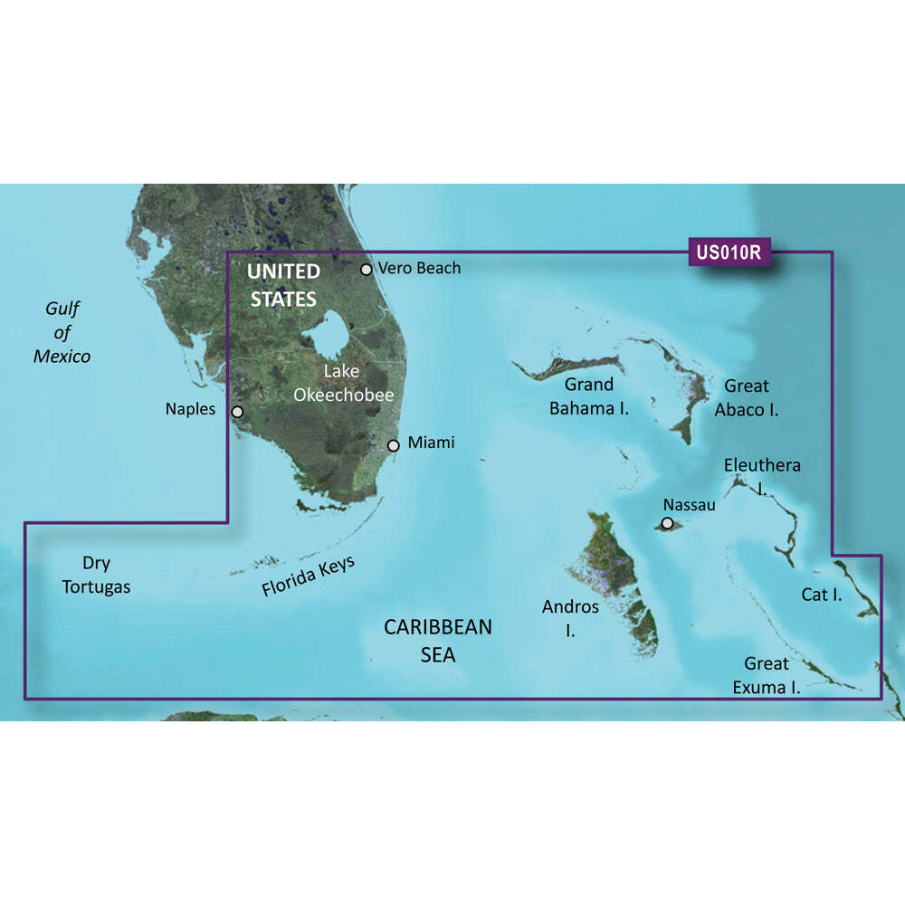
Garmin BlueChart® g3 Vision® HD - VUS010R - Southeast Florida - microSD™/SD™ - 010-C0711-00Garmin BlueChart® g3 Vision® HD - VUS010R - Southeast Florida - microSD™/SD™ - 010-C0711-00BlueChart® g3 Vision® HD - VUS010R - Southeast Florida - microSD™/SD™ Coverage: Featuring data from Explorer Charts for the Bahamas. Vero Beach south to include Lake Okeechobee, Florida Keys, Dry Tortugas, and covering the west coast of Florida north to Naples. Also covered all the Bahamas, Andros Island, Eleuthera Island, Cat Island, Great Exuma Island, Little Exuma Island, and Hog Cay. Premier Coastal Navigation Charts Provides industry-leading coverage, clarity and detail with updated coastal charts that feature integrated Garmin and Navionics® data Auto Guidance¹ technology uses your desired depth and overhead clearance to calculate routes and show a suggested path to follow High-resolution relief shading combines color and shadow to give you an easy-to-interpret, clearer view of bottom structure than contour lines alone Depth Range Shading provides up to 10 depth ranges, enabling you to view your target depth at a glance Up to 1’ contours provide a more accurate depiction of the bottom structure for improved fishing charts and navigation in swamps, canals and marinas Experience unparalleled coverage and brilliant detail on the water. BlueChart g3 Vision coastal charts provide industry-leading coverage, clarity and detail with integrated Garmin and Navionics data, Auto Guidance technology and high-resolution relief shading.. Auto Guidance Technology The Auto Guidance feature¹ uses your desired depth and overhead clearance to calculate a route and a suggested path to follow. High-resolution Relief Shading Feature High-resolution relief shading combines color and shadow to give you an easy-to-interpret, clearer view of bottom structure than contour lines alone. Up to 1’ Contours The closer the contour lines, the more accurate the depiction of the bottom structure for improved fishing charts and navigation in swamps, canals and marinas. NOAA Raster Cartography If you prefer your display to have the look of paper charts, NOAA raster cartography 2 is available as a free downloadable feature via the ActiveCaptain® app. Depth Range Shading This feature provides up to 10 depth ranges, enabling you to view your target depth at a glance. Shallow Water Shading This feature allows you to use shading to designate the shallow water depths you need to avoid. High-resolution Satellite Imagery These detailed images of ports, marinas, bridges and navigational landmarks help provide you with superior situational awareness. Unique 3-D Views MarinerEye and FishEye views provide additional perspective both above and below the water line. ¹Auto Guidance is for planning purposes only and does not replace safe navigation operations ²Raster cartography cannot be viewed on echoMAP CHIRP and ECHOMAP Plus combos but can be viewed on mobile devices via the ActiveCaptain mobile app WARNING: This product can expose you to chemicals which are known to the State of California to cause cancer, birth defects or other reproductive harm. For more information go to P65Warnings.ca.gov . This product may not be returned to the original point of purchase. Please contact the manufacturer directly with any issues or concerns.Specifications Brand Garmin Manufacturer Part Number 010-C0711-00 UPC 753759068912 Product ResourcesOwners Manual (pdf) Url Garmin BlueChart® g3 Vision® HD - VUS010R - Southeast Florida - microSD™/SD™ - 010-C0711-00 Garmin BlueChart® g3 Vision® HD - VUS010R - Southeast Florida - microSD™/SD™ - 010-C0711-00
BlueChart® g3 Vision® HD - VUS010R - Southeast Florida - microSD™/SD™ Coverage: Featuring data from Explorer Charts for the Bahamas. Vero Beach south to include Lake Okeechobee, Florida Keys, Dry Tortugas, and covering the west coast of Florida north to Naples. Also covered all the Bahamas, Andros Island, Eleuthera Island, Cat Island, Great Exuma Island, Little Exuma Island, and Hog Cay. Premier Coastal Navigation Charts Provides industry-leading coverage, clarity and detail with updated coastal charts that feature integrated Garmin and Navionics® data Auto Guidance¹ technology uses your desired depth and overhead clearance to calculate routes and show a suggested path to follow High-resolution relief shading combines color and shadow to give you an easy-to-interpret, clearer view of bottom structure than contour lines alone Depth Range Shading provides up to 10 depth ranges, enabling you to view your target depth at a glance Up to 1’ contours provide a more accurate depiction of the bottom structure for improved fishing charts and navigation in swamps, canals and marinas Experience unparalleled coverage and brilliant detail on the water. BlueChart g3 Vision coastal charts provide industry-leading coverage, clarity and detail with integrated Garmin and Navionics data, Auto Guidance technology and high-resolution relief shading.. Auto Guidance Technology The Auto Guidance feature¹ uses your desired depth and overhead clearance to calculate a route and a suggested path to follow. High-resolution Relief Shading Feature High-resolution relief shading combines color and shadow to give you an easy-to-interpret, clearer view of bottom structure than contour lines alone. Up to 1’ Contours The closer the contour lines, the more accurate the depiction of the bottom structure for improved fishing charts and navigation in swamps, canals and marinas. NOAA Raster Cartography If you prefer your display to have the look of paper charts, NOAA raster cartography 2 is available as a free downloadable feature via the ActiveCaptain® app. Depth Range Shading This feature provides up to 10 depth ranges, enabling you to view your target depth at a glance. Shallow Water Shading This feature allows you to use shading to designate the shallow water depths you need to avoid. High-resolution Satellite Imagery These detailed images of ports, marinas, bridges and navigational landmarks help provide you with superior situational awareness. Unique 3-D Views MarinerEye and FishEye views provide additional perspective both above and below the water line. ¹Auto Guidance is for planning purposes only and does not replace safe navigation operations ²Raster cartography cannot be viewed on echoMAP CHIRP and ECHOMAP Plus combos but can be viewed on mobile devices via the ActiveCaptain mobile app WARNING: This product can expose you to chemicals which are known to the State of California to cause cancer, birth defects or other reproductive harm. For more information go to P65Warnings.ca.gov . This product may not be returned to the original point of purchase. Please contact the manufacturer directly with any issues or Part Resources
× × ×
Buy now and save! Shipping info
Click the Shipping & Payments tab above the listing description for more info
Click the Shipping & Payments tab above the listing description for more info!
Additional delivery notes
PICK UP OPTION
Sorry, our items are NOT available for pick-up.
PAYMENT
Immediate payment is required upon selecting \"Buy It Now\" or upon checking out through the cart.
We accept payment via U.S. PayPal accounts and all Major Credit Cards, Debit Cards & Google Pay.
We are legally required to collect sales tax in those states and localities where we maintain a physical presence (nexus).
The applicable amount of sales tax charged to an order will be calculated based on the shipment destination\'s state and local sales tax laws.
Thank you for shopping with us on !
Additional Information
No additional information at this time
Ask seller a question
You might also like Bennett Marine Bennett V351HPU1 Hydraulic Power Unit - 12V Pump Blue Sea Systems Blue Sea 8087 8 Position DC C-Series Panel - Blank Sensar Marine Sensar Boat Monitor w/Bilge Sentry - BMBS700 Victron Energy Victron BMV-700 Battery Monitor - BAM010700000R Contact
To contact our Customer Service Team, simply click the button here and our Customer Service team will be happy to assist.
Ask seller a question
© BGA Wholesale
Shipping & Payments
Click the Shipping & Payments tab above the listing description for more info
Payment
Accepted Payment Methods
Immediate payment is required upon selecting \"Buy It Now\" or upon checking out through the cart.
We accept payment via U.S. PayPal accounts and all Major Credit Cards, Debit Cards & Google Pay.
We are legally required to collect sales tax in those states and localities where we maintain a physical presence (nexus).
The applicable amount of sales tax charged to an order will be calculated based on the shipment destination\'s state and local sales tax laws.
Thank you for shopping with us on !
Returns
Returns are accepted
Items must be returned within 30 days of the sale ending
Seller will pay for return shipping.
integration by