When you click on links to various merchants on this site and make a purchase, this can result in this site earning a commission. Affiliate programs and affiliations include, but are not limited to, the eBay Partner Network.

1951 US Army Topo Map WONSAN North Korea Kalma Pando Peninsula Hamgyŏngnamdo:
$49.99
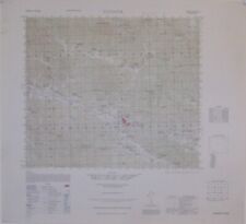
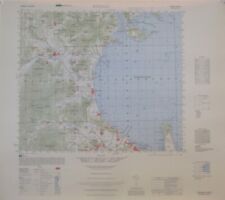
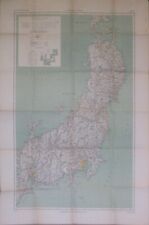
Original 1951 color lithographed topographical map of Wonsan, Munchon,Yonghung Bay, and vicinity, South Hamgyong Province, on North Korea'seastern coast, prepared bythe Army MapService, Corps of Engineers, U.S. Army, Washington, D.C. during theKoreanWar, more than 70years ago. - The map is drawn on a scaleof 1:50,000, and the image areameasures 37 x 43 cm [14½" x 17"], on a sheet measuring 21" x 24".
- The coverage area is bounded by longitude 127°15'10.4" Eto 127°30'10.4" Eand latitude 39°10' N to 39°20' N.
- Details include the Kalma Pando peninsula, where theFirst Marine Division had come ashore seven months before this map wasprinted.
- Other features include roads, railways,lighthouses, rivers, rice paddies, built-up areas, spot elevations, andcontours, at intervals of 20meters.
- The map is titled Wonsan, Korea, Hamgyong-Namdoandis identified as the Third Edition of Sheet 6631 I, printed by Army MapService, Corps of Engineers, 5-51.
- Condition: It is in excellent condition,bright and clean, with no marks, rips, or tears. Itis blank onthe back, with no printing on the reverse side. Please see thescansand feelfree to ask any questions.
- The map has never been folded, and we will ship it to youcarefully rolled in a sturdycardboard tube.
- This is an original, authentic 1951 map, nota reproduction or modern reprint, and it is fully guaranteed to begenuine.
- It was published during the Blockade of Wonsan, or theSiege of Wonsan — thelongest naval blockade in modern history, lasting 861 days. UnitedNations navalforces, primarily from the United States, successfully kept thestrategically important city of Wonsan from being used by the NorthKorean Navy.
- Buy with confidence! We are always happy to combineshipping on thepurchase of multiple items — just make sure to pay for everythingat one time, not individually.
Powered by SixBit's eCommerce Solution
|