When you click on links to various merchants on this site and make a purchase, this can result in this site earning a commission. Affiliate programs and affiliations include, but are not limited to, the eBay Partner Network.
49.5 x 36 cm (19.5 x 14 in)
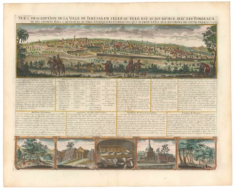
This informative broadside, entitled View and description of Jerusalem, was produced and published by the Chatelain family in the early 18th century. As with most of Chatelain\'s output, the aesthetic qualities of the composition and engraving are held to the highest standards. The image is divided into three registers, of which the top is the largest and most important. This provides a full panoramic view of the ancient city of Jerusalem, as seen from the Mount of Olives. In the forefront, mounted and pedestrian characters help bring the scene to life. Within the meticulously depicted walled cityscape, a range of landmarks stand out. Many of these are numbered and linked to an explanatory key in the text below. Among the most prominent buildings, we find the Dome of the Rock in the center of the composition, flanked on its left (south) by the al-Aqsa Mosque.
In the second or middle register, an extensive text in French provides us with a wealth of information about Jerusalem and its holy sites. There is a general description and a legend associated with the numbered key. Also present are dedicated sections on the tombs of Zacharias (father of John the Baptist), Absalom (third son of King David), and Queen Helene of Adiabene (Tombeaux des Rois). While the two first structures are located near each other in the Kieron Valley, the ‘Tombs of the Kings\' constitutes a rock-cut funerary complex in East Jerusalem. Each of the three sites is represented pictorially in one of five smaller scenes that form the lower register. Flanked on either side by views of Mount Lebanon, we find evocative vignettes depicting the two mausolea and the rock-cut sepulcher in Jerusalem.Census
The copper-engraved view comes from fifth volume of the Chatelain family\'s seminal seven-volume Atlas Historique, ou Nouvelle Introduction A l\'Histoire, à la Chronologie and; à la Geographie Ancienne and; Moderne; ... Tome V. Qui comprend l\'Asie en general et en particulier, l\'Assyrie, l\'Armenie, la Georgie, la Turquie Asiatique, la Terre-sainte, l\'Arabie, la Perse, la Tartarie, les Etats Japon, et le Roïaume de Siam (1719). The atlas combines the finest engraving and cartographic craftsmanship with academic studies of geography, history, ethnology, heraldry, and cosmography and was one of the most widely distributed atlases in the 18th century. While not the case with this view, the maps of the Atlas Historique were based mainly on the work of French cartographer Guillaume De L\'Isle. Chatelain nevertheless developed his distinct aesthetic for his maps and presented the accompanying information in an almost encyclopedic form.