Heat.net Store Home
|
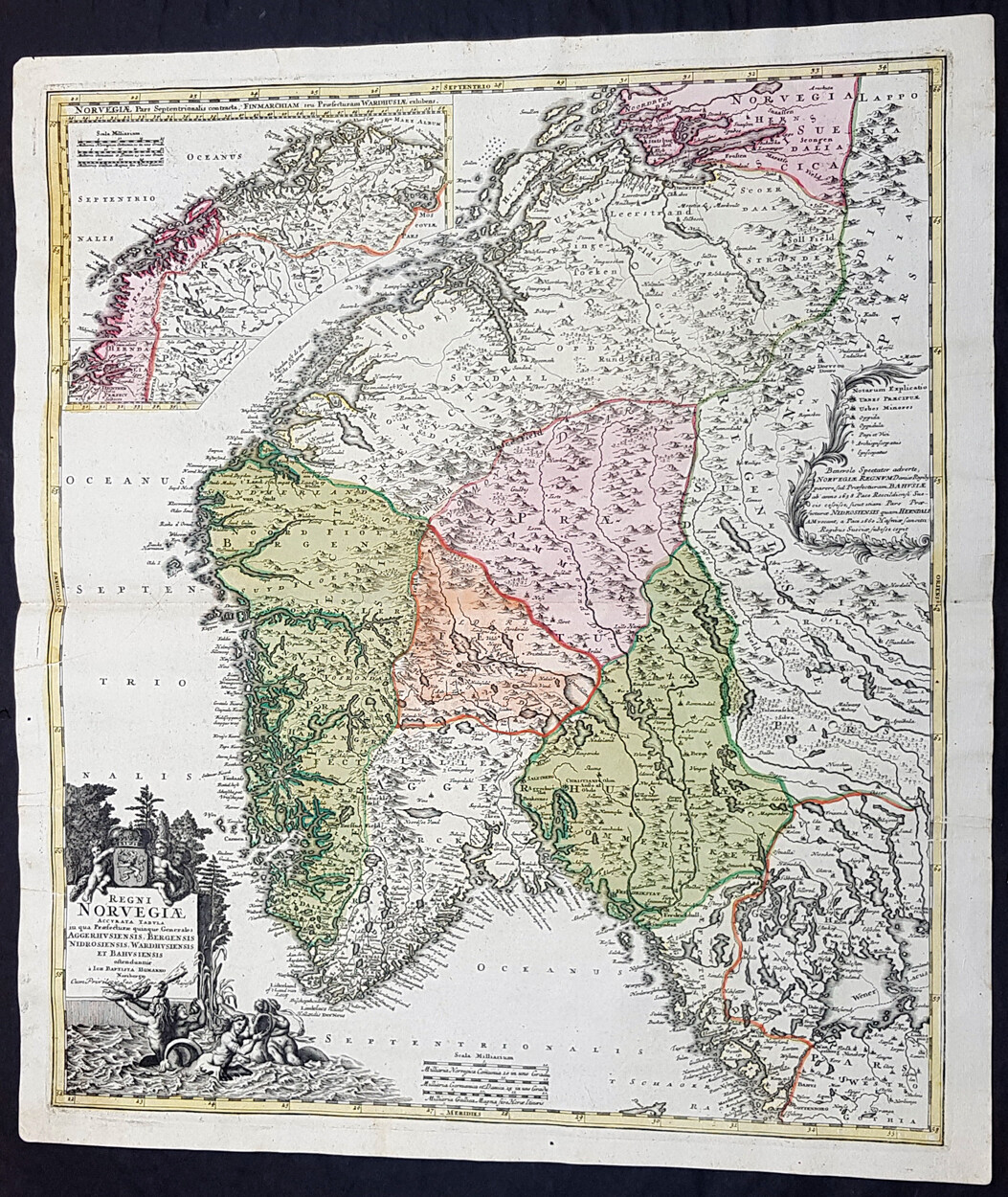
1720 J B Homann Large Original Antique Map of Norway - Regni Norvegiae For Sale

When you click on links to various merchants on this site and make a purchase, this can result in this site earning a commission. Affiliate programs and affiliations include, but are not limited to, the eBay Partner Network.

1720 J B Homann Large Original Antique Map of Norway - Regni Norvegiae:
$725.00
Regni Norvegiae Accurata Tabula in qua Praefecturae Quinque Generales Aggerhusiensis, Bergensis Nidrosiensis, Wardhusiensis et Bahusiensi Ioh. Bapt. Homanno.Cartographer : - Homann, Johann Baptist 1663-1724. - Date: - 1720
- Size: - 24in x 20 1/4in (610mm x 540mm)
- Ref#: - 93358
- Condition: - (A+) Fine large beautifully hand coloured original antique map of Norway & parts of Scandinavia - with an inset map of Lapland & Northern Norway - was published by Johann Baptist Homann in 1720.
General Definitions:
Paper thickness and quality: - Heavy and stable
Paper color : - off white
Age of map color: - Original
Colors used: - Blue, pink, red, green, yellow
General color appearance: - Authentic
Paper size: - 24in x 20 1/4in (610mm x 540mm)
Plate size: - 23 1/2in x 20in (595mm x 505mm)
Margins: - Min 1/2in (12mm) Imperfections:
Margins: - None
Plate area: - None
Verso: - None Background:
Before the fifteenth century the peoples of Southern Europe had little geographical knowledge of the Scandinavian world except from sketchy detail shown in the Catalan Atlas (1375) and on a number of \\\'portolani\\\' embracing Denmark and the southern tip of Norway. It was not until 1427 that a manuscript map prepared about that time by Claudius Clavus (b. 1388), a Dane who had spent some time in Rome, made available to scholars a tolerable outline of the northern countries and Greenland. That was to remain the best map available for the rest of the century and it was used as the basis for maps of Scandinavia in early printed editions of Ptolemy. Others by Nicolaus Cusanus (1491) and Ehrhard Etzlaub (c. 1492) followed but, needless to say, these are extremely rare; even the later maps by Olaus Magnus and Marcus Jordan, where they have survived at all, are known only by very few examples. In fact, apart from the rare appearance of an early Ptolemy map, the oldest of Scandinavia which a collector is likely to find are those in Munster\\\'s Cosmography published in 1544 with many later editions. In the following centuries the comparatively few maps and charts compiled in Scandinavia were usually published in Amsterdam, Antwerp, Paris or Nuremberg, the more important maps often being incorporated in the major Dutch, French and German atlases. (Ref: Tooley; M&B)Homann, Johann Baptist 1663-1724.
Homann Heirs 1700-1780.
Following the long period of Dutch domination, the Homann family became the most important map publishers in Germany in the eighteenth century, the business being founded by J.B. Homann in Nuremberg about the year 1702. Soon after publishing his first atlas in 1707 he became a member of the Berlin academy of Sciences and in 1715 he was appointed Geographer to the Emperor. After the founder\\\'s death in 1724, the firm was continued under the direction of his son until 1730 and was then bequeathed to his heirs on the condition that it trades under the name of Homann Heirs. The firm remained in being until the next century and had a wide influence on map publishing in Germany. Apart from the atlases the firm published a very large number of individual maps.
The Homman\\\'s produced a Neuer Atlas in 1714, a Grosser Atlas in 1737, and an Atlas Maior with about 300 maps in 1780. They also issued a special Atlas of Germany with full sized plans of principal cities, school atlases and an Atlas of Silesia in 1750 with 20 maps.
What is an Antique MapThe word Antique in the traditional sense refers to an item that is more than a hundred years old. In the past maps were sold in two forms, as a single sheet (broadsheet) or bound in an atlas or book. The majority of antique maps for sale today come from books or atlases and have survived due to the protection offered by the hardback covers. When considering a purchase The first thing to determine when staring a collection or purchasing an item, is what is important to you. Most collectors prefer to build their collections around a theme. You may decide to collect maps from one region or country, charting its development through time. Similarly you could collect maps of one particular period in time, by type (i.e. sea or celestial charts) or by cartographer. The collector might also want to consider the theme of cartographical misconceptions such as California as an island or Australia as Terra Australis or the Great Southern Land.
The subject is so wide that any would-be-collector has almost endless possibilities to find his own little niche within the field, and thereby build a rewarding collection. Starting a collection & pricingPricing is based on a number of different factors, the most important of which is regional. In any series of maps the most valuable are usually the World Map and the America/North America. The World because it is usually the most decorative and America because it has the strongest regional market. Other factors that come into play re: price is rarity, age, size, historical importance, decorative value (colour) and overall condition and quality of paper it is printed on.
As specialised dealers, we frequently work with first time map buyers who are just starting their collection. Guiding new collectors on their first antique map purchase and helping new collectors to focus their interests is one of the most rewarding aspects of being an rare map dealer. So please do not hesitate to contact us and we will be happy to help with any questions you may have. Payment, Shipping & Return OptionsPlease click on the \\\"Shipping and Payments\\\" Tab above for shipping, payment and return details About USClassical Images was founded 1998 and has built an excellent reputation for supplying high quality original antiquarian maps, historical atlases, antique books and prints. We carry an extensive inventory of antiquarian collectibles from the 15th to 19th century. Our collection typically includes rare books and decorative antique maps and prints by renowned cartographers, authors and engravers. Specific items not listed may be sourced on request.
Classical Images adheres to the Codes of Ethics outlined by the Antiquarian Booksellers Association of America (ABAA).
We are a primarily an online based enterprise, however our inventory may be viewed by appointment. Please call or email to arrange a Sellers - Get Templates
Image Hosting, Scheduling at Auctiva.com.
Track Page Views With
Auctiva\'s FREE Counter
|
|
Other Related Items:
Related Items:
Robertshaw 1720-801 Gas Cooking Electromagnet Replace Kit, J $143.99
1720 J B Homann Large Original Antique Map of Norway - Regni Norvegiae $725.00
Bailey 1720J1H Linear Amplifier Adjustable 0-70% Full Power Indicator $139.99
|
