Heat.net Store Home
|
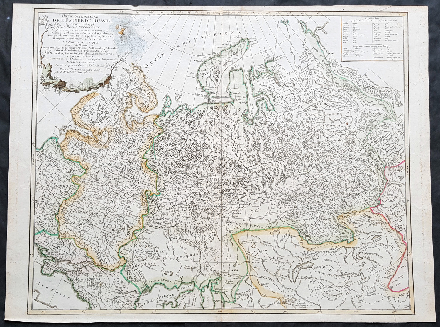
1757 Robert De Vaugondy Large Antique Map of the Russian Empire - Poland to Asia For Sale

When you click on links to various merchants on this site and make a purchase, this can result in this site earning a commission. Affiliate programs and affiliations include, but are not limited to, the eBay Partner Network.

1757 Robert De Vaugondy Large Antique Map of the Russian Empire - Poland to Asia:
$350.00
Partie Occidentale De L Empire De Russie...Sr Robert De VaugondyCartographer : - De Vaugondy, Gilles Robert 1688 - 1766 - Date: - 1757
- Size: - 26in x 20in (660mm x 510mm)
- Ref#: - 41592
- Condition: - (A+) Fine large magnificent hand coloured original copper-plate engraved antique map of The Russian Empire - stretching from Poland to Central Asia - by Robert De Vaugondy was published in the 1757 edition of De Vaugondys famous The Atlas Universel
General Definitions:
Paper thickness and quality: - Heavy and stable
Paper color : - off white
Age of map color: - Original & later
Colors used: - Blue, pink, red, green, yellow
General color appearance: - Authentic
Paper size: - 23 1/2in x 19 1/2in (600mm x 495mm)
Plate size: - 23in x 19 1/2in (585mm x 495mm)
Margins: - Min 1/4in (5mm) Imperfections:
Margins: - None
Plate area: - None
Verso: - None Background:
It is scarcely necessary to look at a map of Russia - with which we must include Siberia - to visualize the daunting task facing Russian map makers. Indeed, considering the vastness of their territory and the lack of skilled cartographers, it is surprising that relatively good maps were available for engraving and printing in most of the well known sixteenth and seventeenth century atlases. Generally, maps of that time were based on material brought back from Moscow by visitors from the West.De Vaugondy, Gilles Robert 1688 - 1766
Didier Robert 1723 - 86
Gilles and Didier Robert De Vaugondy were father and son, respectively, and produced their atlas, globes and maps in concert. In many cases they did not use the initials of their first names when signing their maps, so it can be unclear at times who made a given map. On some maps fils or filio follows the name, designating its author as the son. In other instances, the authorship can be determined by the distinctive way each signed his maps: the father normally used \\\\\\\"M.Robert,\\\\\\\" leaving off the last name, and the son, \\\\\\\"Robert de Vaugondy.\\\\\\\" The Atlas Universal [Paris, 1757] was one of the most important 18th century atlases and one of the great achievements of the French Enlightenment.
The Vaugondy\\\\\\\'s employed strict standards for including maps in this atlas and in many cases subjected them to astronomically derived readings for latitude and longitude. Moreover, \\\\\\\'their frequent use of eighteenth century sources, often from the 1740s, provided their atlas with up-to-date information. While their preference was for maps that bad been surveyed in the field and maps published in the region itself, they did not hesitate to turn to older sources when more recent maps were found to be lacking.\\\\\\\" (Pedley, p. 61) For their maps of Canada and South America, the Vaugondy\\\\\\\'s had access to sources held by the Depot de la Marine, the official French repository for maritime-related information. Like Ortelius and Mercator before them, the Vaugondy`s listed the sources of their maps, which is of incalculable benefit to anyone seeking to understand not only their maps but also those of the period.
\\\\\\\"A feature of the maps of the Atlas Universel which attracted unanimous praise from critics was the cartouches.\\\\\\\" (Pedley, p. 64) A number of artisans worked on their design and engraving; several cartouches were engraved and signed by the Haussard sisters. Among the most pictorial cartouches are the four found on maps showing the postal routes of Great Britain, France, Germany, Spain and Portugal. They depict postal carriers en route in richly detailed settings.Please note all items saleed are genuine, we do not sell reproductions. A Certificate of Authenticity (COA) can be issued on request.
What is an Antique MapThe word Antique in the traditional sense refers to an item that is more than a hundred years old. In the past maps were sold in two forms, as a single sheet (broadsheet) or bound in an atlas or book. The majority of antique maps for sale today come from books or atlases and have survived due to the protection offered by the hardback covers. When considering a purchase The first thing to determine when staring a collection or purchasing an item, is what is important to you. Most collectors prefer to build their collections around a theme. You may decide to collect maps from one region or country, charting its development through time. Similarly you could collect maps of one particular period in time, by type (i.e. sea or celestial charts) or by cartographer. The collector might also want to consider the theme of cartographical misconceptions such as California as an island or Australia as Terra Australis or the Great Southern Land.
The subject is so wide that any would-be-collector has almost endless possibilities to find his own little niche within the field, and thereby build a rewarding collection. Starting a collection & pricingPricing is based on a number of different factors, the most important of which is regional. In any series of maps the most valuable are usually the World Map and the America/North America. The World because it is usually the most decorative and America because it has the strongest regional market. Other factors that come into play re: price is rarity, age, size, historical importance, decorative value (colour) and overall condition and quality of paper it is printed on.
As specialised dealers, we frequently work with first time map buyers who are just starting their collection. Guiding new collectors on their first antique map purchase and helping new collectors to focus their interests is one of the most rewarding aspects of being an rare map dealer. So please do not hesitate to contact us and we will be happy to help with any questions you may have. Payment, Shipping & Return OptionsPlease click on the \\\"Shipping and Payments\\\" Tab above for shipping, payment and return details About USClassical Images was founded 1998 and has built an excellent reputation for supplying high quality original antiquarian maps, historical atlases, antique books and prints. We carry an extensive inventory of antiquarian collectibles from the 15th to 19th century. Our collection typically includes rare books and decorative antique maps and prints by renowned cartographers, authors and engravers. Specific items not listed may be sourced on request.
Classical Images adheres to the Codes of Ethics outlined by the Antiquarian Booksellers Association of America (ABAA).
We are a primarily an online based enterprise, however our inventory may be viewed by appointment. Please call or email to arrange a Sellers - Get Templates
Image Hosting, Scheduling at Auctiva.com.
Track Page Views With
Auctiva\'s FREE Counter
|
|
Other Related Items:
Related Items:
1757 Robert de Vaugondy ATLAS UNIVERSEL Title Page Original Antique Map Print $150.00
1757 Robert De Vaugondy Large Antique Map of Germany ,Germania during Roman Era $175.00
1757 Robert De Vaugondy Large Antique Map of the Russian Empire - Poland to Asia $350.00
|
