When you click on links to various merchants on this site and make a purchase, this can result in this site earning a commission. Affiliate programs and affiliations include, but are not limited to, the eBay Partner Network.
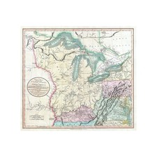
This masterful reproduction of the 1805 John Cary map captures the Great Lakes and Western Territory in vivid detail, showcasing the early routes, settlements, and obstacles that shaped frontier exploration in America’s nascent years.Available in 16x24 inch and 24x36 inch sizes, it fits comfortably in a study, living room, or classroom, blending seamlessly with both vintage and modern decor styles.More than a decorative piece, this map serves as a window into early 19th-century geographic knowledge—depicting treaties, borders, and routes that invite viewers to trace the footsteps of explorers and settlers, making it a valuable educational aid.By highlighting the lands destined to become key Midwestern states, it tells stories of expansion and negotiation that defined a pivotal chapter in American history.Bringing this map into your space adds a sense of character and sparks meaningful dialogue, connecting today’s viewers with the complex history behind the nation’s growth.About the Maker – I’m Paul, an independent printer and vintage image enthusiast working from my home studio. Every order is printed, carefully inspected, hand-packed, and shipped by me, personally. When you shop here, you’re not buying from a faceless company— you’re supporting a real person who takes pride in exceptional print quality, careful packaging, and attentive customer service from start to finish.