When you click on links to various merchants on this site and make a purchase, this can result in this site earning a commission. Affiliate programs and affiliations include, but are not limited to, the eBay Partner Network.
86 x 71 cm (33.85 x 28 in).
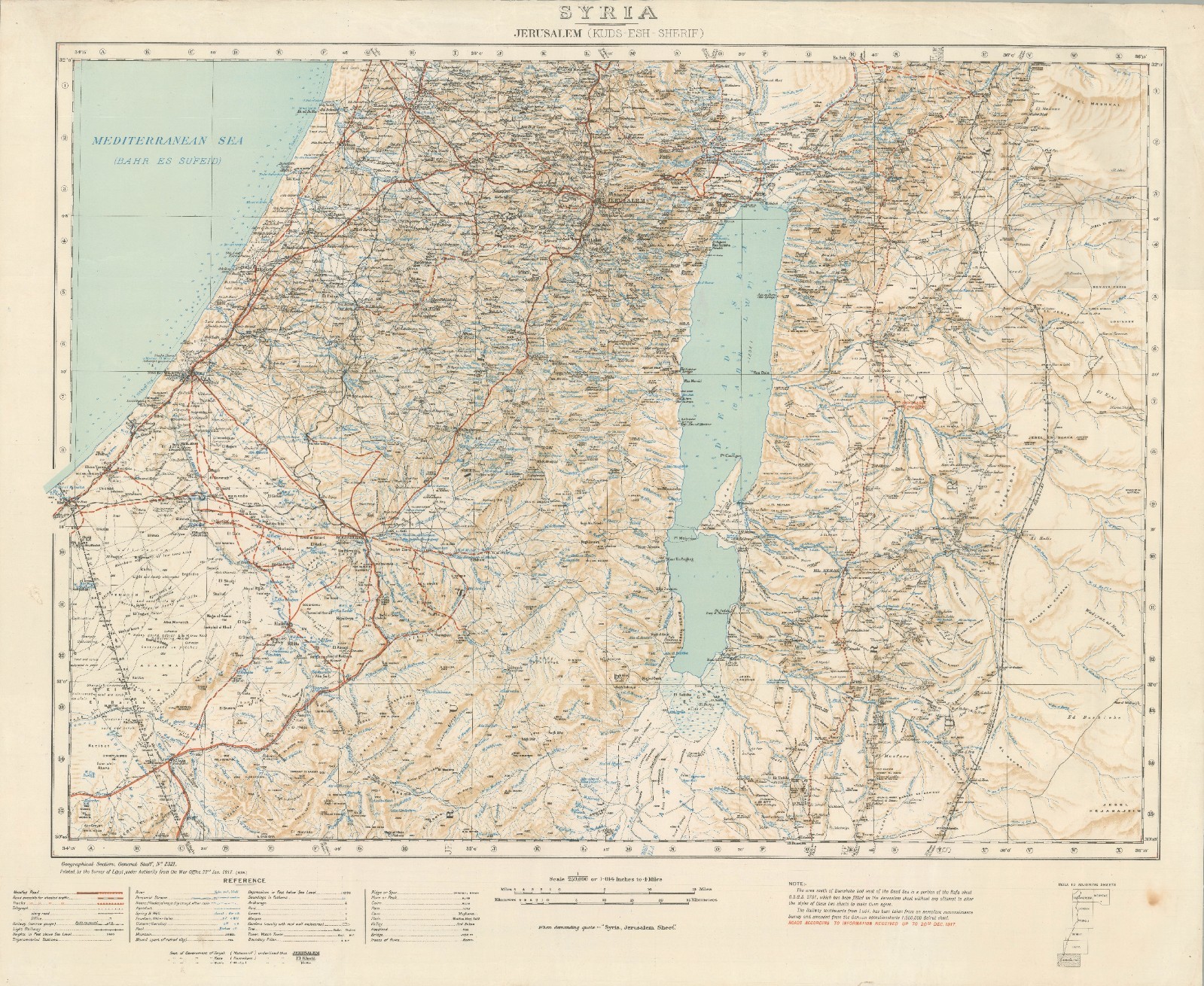
Syria - Jerusalem (Kuds-esh-Sherif), Geographical Section, General Staff No. 2321, 1917.This large and finely detailed 1917 military map of the Jerusalem region coincides with the closing campaigns of the First World War in Palestine.The Map in Detail
This sheet covers from the Mediterranean coast to the hills east of the Dead Sea, stretching from Jaffa and the coastal plain in the west to the highlands of Transjordan in the east, and from the hills north of Jerusalem down to Beersheba and the northern Negev in the south. The Mediterranean Sea, labeled also by its Arabic name \"Bahr es Sufeid,\" occupies the northwest corner, while the Dead Sea, shown in pale blue-green and marked with its Arabic name \"Bahr Lut,\" dominates the eastern half of the sheet, its below-sea-level depression indicated by depth figures. A dense network of wadis, springs, cisterns, and wells is plotted across the map, critical information for an army operating in arid terrain, alongside roads carefully classified in the reference key as metalled roads, roads possible for wheeled traffic, and tracks, together with railways, light railways, telegraph lines, and trigonometrical stations.
Place names appear in their contemporary transliterated Arabic forms, with Jerusalem itself, Beersheba, Hebron (El Khulil), and Jericho prominently marked, and administrative notes identify the seats of government of the sanjak, kaza, and kaimakam districts. Marginal notes explain that the area south of Beersheba and west of the Dead Sea was taken from the adjoining Rafa sheet without full reconciliation of style, that the railway south of Ludd was compiled from aeroplane reconnaissance and the German 1:400,000 Beirut operations map, and, in red, that roads are shown according to information received up to 20 December 1917, a date that places the map squarely in the midst of the fighting for the city.Historical Context
This sheet documents the ground over which the British Egyptian Expeditionary Force, under General Sir Edmund Allenby, fought its way north from Gaza and Beersheba toward Jerusalem in the autumn and winter of 1917. Following the capture of Beersheba in October and Gaza in November, British and Dominion forces pushed through the Judean hills in a grueling series of engagements fought in rain, mud, and difficult highland terrain, culminating in the surrender of Jerusalem on 9 December 1917, which Allenby entered on foot two days later out of respect for the holy city. The map\'s compilation date of January 1917, with its roads updated to late December, places it right at this pivotal moment, and its evident reliance on aerial reconnaissance and captured German survey material, explicitly credited in the marginal notes, reflects the hurried, improvisational intelligence work that characterized mapping for this campaign. The fall of Jerusalem was a major propaganda and strategic victory for Britain, ending four centuries of Ottoman rule over the city and opening the way for the subsequent advance into Syria that would take Damascus the following autumn.Publication History and Census
Issued by the Geographical Section of the General Staff as sheet No. 2321, it was printed by the Survey of Egypt under authority from the War Office, with the printing date of 22 January 1917 recorded at lower left. Like other wartime General Staff maps, it was produced for operational and staff use rather than public sale. A small handful of examples are cataloged at libraries and institutions, mostly in the U.K.