When you click on links to various merchants on this site and make a purchase, this can result in this site earning a commission. Affiliate programs and affiliations include, but are not limited to, the eBay Partner Network.
Geographic coverage: Chile from the Atacama Desert south through Santiago, Concepción, Valdivia, and the island of Chiloé, including the Andes and the Juan Fernández Islands in the Pacific.
Technique: Copperplate engraving with hand coloring along the coastline, mountain ranges, and selected geographical features.
Historical interest: Particularly noteworthy for the early geography of colonial Chile, the Atacama Desert, Spanish settlements, the Andes, the Juan Fernández Islands, and the territories of the Indigenous Mapuche peoples.
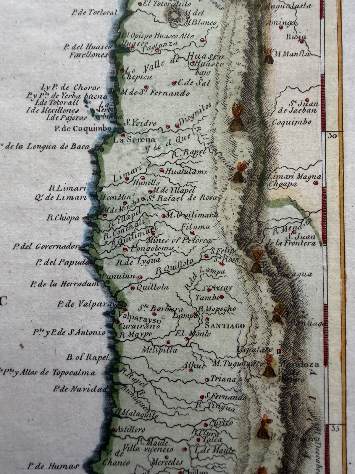
The map is unusual visually because the Pacific Ocean occupies most of the sheet, while the narrow strip of Chilean territory is concentrated along the right edge. This effectively emphasizes Chile’s extraordinary north-to-south geography between the Pacific and the Andes.
Condition: Appears to be a good example with broad margins, attractive coloring, minor scattered spotting and toning, and some soft paper creases. The engraved border appears complete.
Is anonymous published in Boston 1812.
I found a particularly relevant catalog listing for a map titled Chili by John Pinkerton, published in London in 1809.
The catalog describes precisely the same geographic coverage visible on this sheet: Atacama to Chiloé, the Juan Fernández Islands, Santiago, Concepción, Valdivia, and the heavily shaded Andes.
Chile Pinkerton c1809 South America Pacific Andes Hand Color Antique Map
CHILE — SOUTH AMERICA, PACIFIC COAST AND ANDES — c.1812
An attractive early 19th-century engraved map of Chile, with hand coloring highlighting the Pacific coastline, the Andes Mountains, and selected geographical features. Titled simply Chili, the map presents a detailed view of colonial Chile extending from the Atacama Desert in the north to the island of Chiloé in the south.
The map is provisionally attributed to the cartographic tradition of John Pinkerton, whose important geographical publications appeared in London during the early 19th century.
The engraving is particularly distinctive for its composition, with the vast South Pacific Ocean occupying much of the sheet and the long, narrow territory of Chile extending down the eastern edge. The Andes are shown as a continuous, heavily shaded mountain barrier, dramatically illustrating the geographical isolation of Chile between the mountains and the Pacific.
Numerous towns, ports, rivers, and geographical features are identified, including Santiago, Valparaiso, Coquimbo, Copiapó, Concepción, Valdivia, and Chiloé. The Juan Fernández Islands are shown far offshore in the Pacific, including the island historically associated with the marooned Scottish sailor Alexander Selkirk.
Historical Background — Chile Under Spanish Colonial Rule
At the beginning of the 19th century, Chile remained part of the Spanish colonial empire, administered as the Captaincy General of Chile. Its territory was geographically isolated from much of Spanish South America by the formidable Andes Mountains to the east, the Atacama Desert to the north, and the Pacific Ocean to the west.
Santiago, founded by Pedro de Valdivia in 1541, had developed into the principal administrative and political center of the colony. Valparaiso served as its important Pacific port, while Concepción was a major southern settlement and military center.
The map records a landscape shaped by nearly three centuries of Spanish colonial settlement, Indigenous resistance, and expanding European geographical knowledge.
Particularly significant is the southern region around Concepción and Valdivia, where Spanish colonial expansion encountered sustained resistance from the Mapuche peoples. The long series of conflicts collectively known as the Arauco War had begun in the 16th century and continued, with periods of warfare and negotiated peace, throughout the colonial era.
Much of the territory south of the Biobío River remained outside effective Spanish control. This frontier was one of the most enduring political and cultural boundaries in colonial South America.
The map also identifies the island of Chiloé, which developed as an important Spanish outpost and maritime center. Its relative isolation from the rest of Chile gave the island a distinctive colonial history and cultural character.
The Juan Fernández Islands and the Story of Robinson Crusoe
One of the map’s most interesting features is the depiction of the Juan Fernández Islands, situated far offshore in the Pacific Ocean.
These islands became internationally famous through the story of Alexander Selkirk, the Scottish sailor who was marooned on one of the islands from 1704 until 1709.
Selkirk’s experiences helped inspire Daniel Defoe’s celebrated novel Robinson Crusoe, first published in 1719.
The appearance of the islands on this map connects Chilean geography with one of the most famous maritime survival stories in literary history.
Chile on the Eve of Independence
If published around 1809, this map dates to the final years of Spanish colonial administration, immediately preceding the beginning of Chile’s independence movement in 1810.
The establishment of the First Government Junta in Santiago in September 1810 marked the beginning of the political process that ultimately led to Chilean independence.
After years of conflict between royalist and patriot forces, Chile formally declared independence in 1818.
The map therefore preserves the geographical appearance of Chile during a period of profound political transformation, shortly before the emergence of the modern Chilean republic.
Cartographic Features
The map is engraved with considerable attention to the geographical detail of Chile’s long Pacific coastline. Numerous rivers, bays, coastal settlements, and inland towns are individually named.
The Andes are prominently rendered through dark engraved mountain shading, while the coastline is outlined in attractive hand color. Latitude and longitude markings appear along the neatline border, and the title Chili is enclosed within a simple engraved cartouche in the lower-left portion of the map.
The unusually spacious depiction of the Pacific Ocean emphasizes the maritime geography of Chile and the importance of its ports and offshore islands.
An appealing original antique map of Chile, combining early South American geography, Spanish colonial history, the Andes Mountains, the Juan Fernández Islands, and the period immediately preceding Chilean independence.
Condition: Attractive hand coloring, broad margins, light scattered age toning and spotting, minor paper creases and handling wear. The engraved border appears complete. Please examine the photograph for condition details.
Map sheet measures c.
printed engraved area c.
R36838