When you click on links to various merchants on this site and make a purchase, this can result in this site earning a commission. Affiliate programs and affiliations include, but are not limited to, the eBay Partner Network.
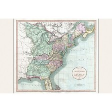
This expertly reproduced map by John Cary from 1806 reveals a detailed vision of the United States east of the Mississippi River, alongside parts of the Louisiana Territory and Canada. It captures a moment when the vast \"Western Territory\" stretched across modern Ohio, Indiana, Michigan, Wisconsin, Illinois, and parts of Minnesota, regions then sparsely settled and marked by fur trading outposts.Available in 16x24 inch or 24x36 inch dimensions, this map suits vintage, scholarly, and classic decor styles, inviting quiet reflection in study rooms or educational spaces. Its extensive annotations on river routes, forts, roads, and territorial boundaries offer a rich resource for classrooms exploring early American history and geography.This map carries an aura of exploration and the unfolding story of a young nation. Placed on your wall, it becomes a conversation piece and a window into the past, encouraging both learning and appreciation.About the Maker – I’m Paul, an independent printer and vintage image enthusiast working from my home studio. Every order is printed, carefully inspected, hand-packed, and shipped by me, personally. When you shop here, you’re not buying from a faceless company— you’re supporting a real person who takes pride in exceptional print quality, careful packaging, and attentive customer service from start to finish.