Heat.net Store Home
|
Huge 17\"x21\" Copper Wall Art Industrial Map Decor 1939 USGS Brussels MO IL For Sale


When you click on links to various merchants on this site and make a purchase, this can result in this site earning a commission. Affiliate programs and affiliations include, but are not limited to, the eBay Partner Network.

Huge 17\"x21\" Copper Wall Art Industrial Map Decor 1939 USGS Brussels MO IL:
$417.99
Authentic Masterpiece of American Cartographic & Military History — Brussels Quadrangle Complete 3-Plate Set This listing is for a rare, museum-grade, matching 3-piece complete master production archive of solid copper printing plates used by the U.S. Geological Survey (USGS) to manufacture the Brussels, Missouri / Illinois 15-Minute Series map, officially published in 1939. The last photo is an example of what the printed map would look like using these 3 plates to create the map. It is for reference only and is not included in the sale. These heavy, solid copper plates represent the complete color-separation layers used in the historic multi-step lithographic process to print topographic maps. This seamless 3-plate set consists of: The Culture/Infrastructure Plate: Features the top-margin hand-etched script \"Brussels 3491\". This holds the incredibly dense, mirrored engravings for the town grids, structures, labels, and local rail/road lines (Printed in Black ink). The Topographic Terrain Plate: Stamped and etched on the top right margin \"Brussels Brown 3491\", stamped in the upper middle \"Brussels 3491\", and features the original historic worker\'s layout code \"Brussels 3491\" handwritten across the top in vintage wax pencil. Intricately hand-engraved with sweeping, fluid contour lines mapping the physical elevation changes and bluffs of the river valleys (Printed in Brown ink). The Hydrography Plate: Stamped and etched on the top right margin \"Brussels Blue 3491\", stamped in the upper middle \"Brussels 3491\", and carries matching top-margin vintage wax pencil identification markings. Deeply incised with the complex network of local creeks, river bends, and drainage basins (Printed in Blue ink).
Geographic and Technical Significance The Brussels quadrangle captures a massive geographic choke-point: the narrow peninsula of Calhoun County, Illinois, right at the legendary confluence where the Illinois River empties into the Mississippi River, splitting Illinois from St. Charles County, Missouri. This set is an engineer\'s dream, featuring an incredibly complex mathematical border setup. It holds three separate grid systems carved into the margins: The 5,000-Yard System C Grid: An early US Army field artillery tracking grid used to calculate long-range military defense firing lines. The Dual-State 10,000-Foot Grid: A cutting-edge coordinate network bridging both the Missouri East and Illinois West tracking frameworks on a single map Archival Margin Stamps Top Left Stamp: \"Missouri-Illinois, Brussels Quadrangle, 15 Minute Series\" Bottom Left Tracking: \"Brussels, Mo.-Ill., N3842-W9030/15, 1939\"(Denoting exact Global Coordinates at Lat N 38°42\' / Long W 90°30\'). The Interwar Engineering Crew: Stamped \"Topography by Frank W. Hughes, J.C. Hilliard, S.B. O’Hara, and W.B. Brewer, Surveyed in 1927 and 1939\"—the legendary regional mapping team for the USGS Central Division.
Visual Appeal: Displays a gorgeous, dark natural patina and fascinating production-floor wax markings. This set looks spectacular when framed as a multi-panel gallery wall, serving as an elite centerpiece for luxury rustic decor, a waterfowl hunting lodge along the Mississippi Flyway, or a high-end corporate office. Terms of Sale: This item is available for Local Pickup Only in Pontiac, Illinois. Due to the significant weight (approx. 30.4 lbs total) and historical value of these artifacts, we are not offering standard carrier shipping
|
|
Other Related Items:
Related Items:
Pancha Tantra Taschen Walton Ford 2007 Signed Limited #1585/1600 HUGE 17" x 21" $940.00
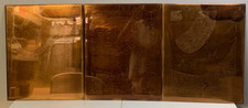
Huge 17"x21" Copper Wall Art Industrial Map Decor 1939 USGS Brussels MO IL $417.99
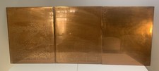
Huge 17" x 21" Vintage Copper Wall Art Industrial Map Decor 1930 USGS Danvers IL $449.99
|
